Japan’s Tsunami Stones: Ancient Warnings Carved in Rock
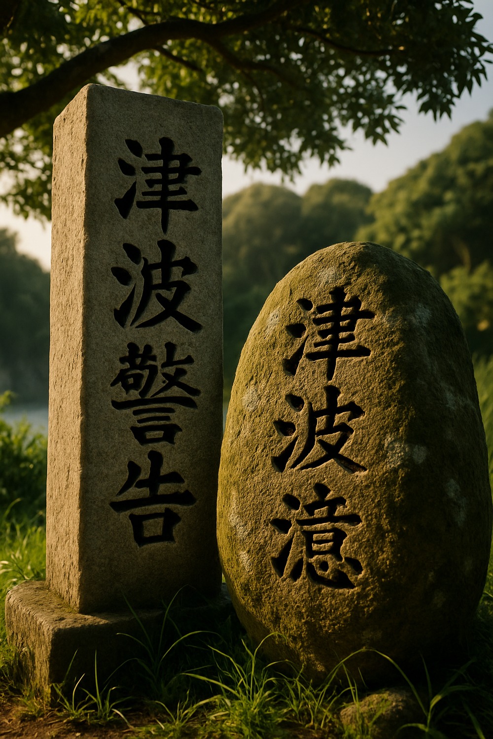
Six centuries of weather have worn the surface rough, but the words cut into that Japan tsunami stone above Aneyoshi still read without ambiguity: “Do not build your homes below this point.” Not a suggestion. Not folklore. A verdict delivered once, in granite, by people who had already watched the sea make its argument.
More than a hundred of these carved stone markers still stand along Japan’s Sanriku coastline, placed there after tsunamis that emptied entire fishing communities. They range from centuries-old monoliths to markers added after the catastrophic 2011 earthquake. Together, they form the longest-running public safety message in human history — written not in a database, not on a government website, but in stone. The question no one has fully answered: why do so many people still build below the line?
Ancient Stones: Japan’s Original Tsunami Warning System
Grief, not government decree, placed the earliest Japan tsunami stones. After the 1896 Meiji Sanriku tsunami — one of the deadliest in Japanese recorded history, killing more than 22,000 people along the northeast coast — survivors and local officials began setting stones in the hillsides above the waterline. According to research by geologist Koji Minoura of Tohoku University, published in a 2001 study in the journal Geology, sediment cores from the Sanriku coast show evidence of massive tsunami inundation events stretching back over a thousand years. The stones weren’t the first attempt to record these disasters. But they were the most visible. The 1896 Meiji Sanriku earthquake generated waves reaching 38 meters in some locations — higher than a twelve-story building.
What’s remarkable isn’t just the stones’ age. It’s their accuracy. The Aneyoshi stone, believed to date to around 1933 following the Showa Sanriku tsunami, marks a boundary that held during the 2011 disaster. Every structure below its warning line was destroyed. Every structure above it survived. That’s not coincidence — it’s multigenerational engineering, carried out not with algorithms or satellite imaging, but with human memory etched into granite. The stone doesn’t explain why the ocean behaves as it does. It doesn’t need to. It just tells you where to stand.
Fishermen along the Sanriku coast had known for generations that the Pacific Rim’s subduction zones make this stretch of coastline one of the most tsunami-prone on Earth. The stones weren’t fear. They were practical geography — telling you exactly what the sea was capable of, and where it would reach when it remembered.
When Memory Fails: The Pattern of Rebuilding Too Close
Here’s the thing: people kept moving back. After the 1896 disaster, many coastal communities rebuilt on higher ground, exactly as the stones advised. But within two generations — by the time the 1933 Showa Sanriku tsunami arrived — villages had crept back toward the waterline. Economic pressure, proximity to fishing grounds, and the slow erosion of living memory all played a role. Historians at Tohoku University have documented this cycle across multiple tsunami events, noting that once a generation passes without catastrophe, the gravitational pull of the coast proves almost impossible to resist.
Why does this matter? Because the same pattern repeats on every hazardous coastline where livelihood and danger share the same geography — from volcano flanks to eroding shorelines — and the Sanriku coast is simply where it’s been recorded the longest. The ocean is the livelihood. The danger is the condition of having the livelihood at all. That tension never fully resolves. It’s part of why stories about humans and dangerous landscapes — whether they involve tsunami stones or the prehistoric hazards buried beneath some of Australia’s most popular beaches — keep demanding to be told.
After 1933, new stones were erected. Some carried more urgent language than the originals, acknowledging that the warnings had been ignored once already. One inscription discovered in Kesennuma reads, roughly translated: “High dwellings are the peace and harmony of our descendants. Remember the calamity of the great tsunamis. Do not build any homes below this point.” The grammar of survival, passed forward. Between 1896 and 2011 — a span of 115 years — the Sanriku coast was struck by major tsunamis in 1896, 1933, and 1960 (the Chilean earthquake triggered a Pacific-wide tsunami reaching Japan). Three devastating reminders within living or near-living memory, and still the shore drew people back.
Oral history researchers have noted that communities where elders actively retold disaster stories tended to retain higher-ground settlement patterns longer than communities where the stories faded. The stones weren’t meant to replace those stories. They were meant to survive when the storytellers couldn’t.
March 11, 2011: The Day the Stones Were Tested
At 2:46 p.m. on March 11, 2011, a magnitude 9.0 earthquake ruptured a 500-kilometer section of the seafloor off Japan’s Tohoku coast. Waves that followed reached heights of up to 40.5 meters in Miyako, Iwate Prefecture — the highest reliably recorded tsunami runup in Japanese history. Nearly 16,000 people died. Entire towns vanished. What the disaster exposed, as National Geographic has documented extensively in the years since, was the gap between what the Japan tsunami stones had recorded and what modern coastal planning had actually enforced. New seawalls that had cost billions of yen to construct were overtopped within minutes. Stone outlasted concrete.
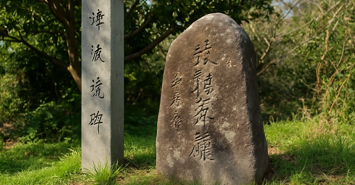
The Japan tsunami stones suddenly became global news. Reporters and researchers converged on the Sanriku coast, photographing and cataloguing markers that many local residents had long treated as scenic curiosities rather than survival instructions. A survey by the Kahoku Shimpo newspaper counted over 100 surviving stones along the northeast coastline. Some had been obscured by vegetation. Some stood in the middle of neighborhoods that had expanded well below the warning lines. A few had been moved — relocated by well-meaning municipal workers who hadn’t understood what they were looking at.
The cruelest finding: in several towns where the stones’ warnings had been followed, there were no casualties from the 2011 waves. Aneyoshi, population roughly 11, lost nothing.
The math was not subtle.
Japan Tsunami Stones in the Modern Era: Memory in a Digital Age
In the aftermath of 2011, Japan’s national and prefectural governments launched systematic efforts to document, restore, and expand the tsunami stone network. Researchers at Tohoku University’s International Research Institute of Disaster Science established digital registries of existing markers and began collaborating with coastal communities to install new stones — this time with GPS coordinates, QR codes, and multilingual inscriptions. By 2023, more than 200 tsunami markers of various types had been catalogued along the Tohoku coastline, a combination of pre-war monoliths and post-2011 installations. The oldest stones carry Japanese text only. The newest include English, Korean, and Chinese — an acknowledgment that the coast now attracts international tourism, and that the warning must reach every visitor who might one day build or settle nearby.
Adding QR codes raises a question the stone-cutters of the 1890s couldn’t have imagined: what happens when the technology that reads the code becomes obsolete? Physical stone has already outlasted several cycles of human memory. It has outlasted the empires and municipal governments that commissioned some of the earliest markers. The new stones assume a reader with a smartphone. But the old stones assumed only a reader with eyes and enough curiosity to stop — and disaster mitigation researchers at Kyoto University’s Disaster Prevention Research Institute have made exactly that point in discussions about intergenerational risk communication. There’s an argument that the older approach is simply more durable.
Some communities have gone further, embedding tsunami markers into school curricula and community festivals. In Kamaishi, a city in Iwate Prefecture that lost over 1,200 residents in 2011, schoolchildren now participate in annual evacuation drills that trace the exact routes their ancestors took to safety. The stones are the start of the lesson. The walk is the rest of it.
Reading the Landscape: What the Stones Still Teach Us
Geoarchaeology — the study of how human communities have encoded environmental knowledge into the physical landscape (researchers actually call this “indigenous disaster science” when its methodology proves empirically rigorous) — counts the Japan tsunami stones among the most sophisticated examples of low-technology risk communication ever devised. Geographer Fumihiko Imamura, a leading tsunami researcher at Tohoku University, has argued that the stones are systematic, empirical, and calibrated to specific topographic conditions. Unlike maps, which require interpretation, or databases, which require maintenance, the stones are self-evident. They sit at the exact boundary they’re describing. The message and the location are the same thing.
Globally, disaster scientists have begun studying the stones as a model for long-term hazard communication. Institutional memory — the kind stored in government archives, engineering reports, and academic papers — degrades faster than the hazard itself. Seismic risk models are updated every decade or so. Building codes change with political administrations. The coast, though, doesn’t change on a human timescale. The subduction zone that generated the 2011 earthquake has been generating tsunamis for millions of years, and a stone placed in 1933 is, in geological terms, practically brand new.
A warning system that outlasts the civilization that built it is not a curiosity — it is the only kind that was ever worth building.
And the Aneyoshi marker makes this timescale visceral. Stand there on a clear autumn morning: below, a scatter of rooftops, rice paddies, a winding road. Above, silence, cedar trees, the stone itself. The sea isn’t visible from here — but the stone knows exactly where it reaches. That knowledge, held in four feet of carved rock, has now survived two generations longer than the people who placed it. If that isn’t science, it’s something very close to it.
How It Unfolded
- 1896 — The Meiji Sanriku tsunami kills over 22,000 people along Japan’s northeast coast, prompting the first systematic placement of carved warning stones in surviving communities.
- 1933 — The Showa Sanriku tsunami strikes the same coastline, killing nearly 3,000; new stones are installed, some explicitly noting that earlier warnings had been ignored and communities had rebuilt too low.
- 2011 — The magnitude 9.0 Tohoku earthquake and tsunami kills nearly 16,000 people and destroys entire towns; the Aneyoshi stone’s warning line is vindicated; global interest in tsunami stones begins.
- 2023 — Tohoku University and prefectural governments complete a digital registry of more than 200 tsunami markers, with new installations featuring QR codes and multilingual text for international visitors.
By the Numbers
- 22,000+ lives lost in the 1896 Meiji Sanriku tsunami, the deadliest in Japan’s recorded pre-war history (Tohoku University Disaster Archives).
- 40.5 meters — the maximum recorded wave runup height during the 2011 Tohoku tsunami, in Miyako, Iwate Prefecture.
- 100+ original tsunami stones documented along the Sanriku coast prior to 2011, many pre-dating World War II.
- 200+ total tsunami markers catalogued along the Tohoku coastline by 2023, a combination of historic stones and new post-2011 installations.
- ¥1.5 trillion (approximately $10 billion USD) — Japan’s estimated investment in coastal seawalls following the 2011 disaster, some exceeding 12 meters in height, yet still shorter than the waves at Aneyoshi.
Field Notes
- In 2014, researchers from the University of Tokyo discovered that one stone near Tarō, Iwate Prefecture, had been relocated by municipal workers in the 1970s — moved slightly downhill during road construction. It no longer marked the actual safe boundary. The adjustment was small. It might have mattered enormously.
- Several tsunami stones carry the phrase “do not forget” in old Japanese script — not as a general caution, but as a specific instruction directed at descendants who had not witnessed the disaster firsthand. Anticipating memory loss was built into the original design.
- Japan’s tsunami stones predate GPS, seismology as a formal discipline, and modern tidal gauges — yet their placement accuracy has been validated by 21st-century satellite mapping of actual inundation zones.
- Researchers still can’t fully explain why some communities honored the stones’ boundaries for multiple generations while others abandoned them within a single lifetime. The variable doesn’t appear to be purely economic. Social memory, storytelling culture, and local leadership all seem to play roles — but the weighting remains unclear.
Frequently Asked Questions
Q: How old are Japan’s tsunami stones, and who made them?
Japan tsunami stones range in age from approximately 600 years old to newly installed markers placed after 2011. The oldest known examples predate formal government recordkeeping and were likely commissioned by local village leaders or Buddhist temple communities. The most widely cited stones date to after the 1896 and 1933 Sanriku tsunamis. The builders weren’t geologists — they were survivors who understood, with terrible precision, exactly how far the water had reached.
Q: Did the tsunami stones actually save lives in 2011?
In documented cases, yes. The village of Aneyoshi, where residents had maintained settlement above the stone’s marked boundary, suffered no casualties during the 2011 tsunami. Researchers from Tohoku University compared inundation maps from 2011 with the locations of historic stone markers and found strong correlation between honored boundaries and reduced fatality rates. The stones didn’t stop the water. They simply told people where not to stand when it arrived — and in the communities that listened, that was enough.
Q: Are there tsunami warning systems like this in other countries?
Not to the same degree of physical permanence. Most countries rely on digital early-warning networks, coastal evacuation signage, and government-issued hazard maps — all of which require functioning infrastructure and active maintenance. Japan’s tsunami stones are unusual because they’re passive, permanent, and self-explanatory. Some Pacific Island communities have oral traditions that encode similar geographic knowledge, but the carved-stone approach appears to be predominantly Japanese in origin and scale. Post-2011, disaster risk researchers have proposed adapting the concept for other tsunami-prone coastlines in Chile, Indonesia, and the Pacific Northwest of the United States.
Editor’s Take — Sarah Blake
What stays with me isn’t the stones themselves. It’s the people who ignored them — not out of ignorance, but out of need, and hope, and the very human conviction that this time it would be different. Every generation seems to believe it has found a way to negotiate with the ocean. The stones don’t argue. They just stand there, patient and exact, waiting to be right again. We keep building below the line. The stones keep counting the years.
Strikingly beautiful — sea stacks, cedar forests, fishing villages draped in morning mist — the Sanriku coast is precisely the kind of place you’d want to build a life. The Japan tsunami stones don’t ask you to leave. They only ask you to remember where the water goes when the Earth decides to shift. In an age when we encode warnings in software that becomes obsolete in a decade, there’s something worth examining in a message that has survived six centuries of weather and still reads clearly. The ocean hasn’t changed its mind. Have we changed ours?