


Three miles of freezing Arctic water separate two islands — and somehow, twenty-one hours. The Diomede Islands International Date Line doesn’t loop around these outcrops the way it bends politely around other territories. It cuts straight through, indifferent to the people it split. One island is American. One is Russian. The line between them is newer than either community’s memory of the other.
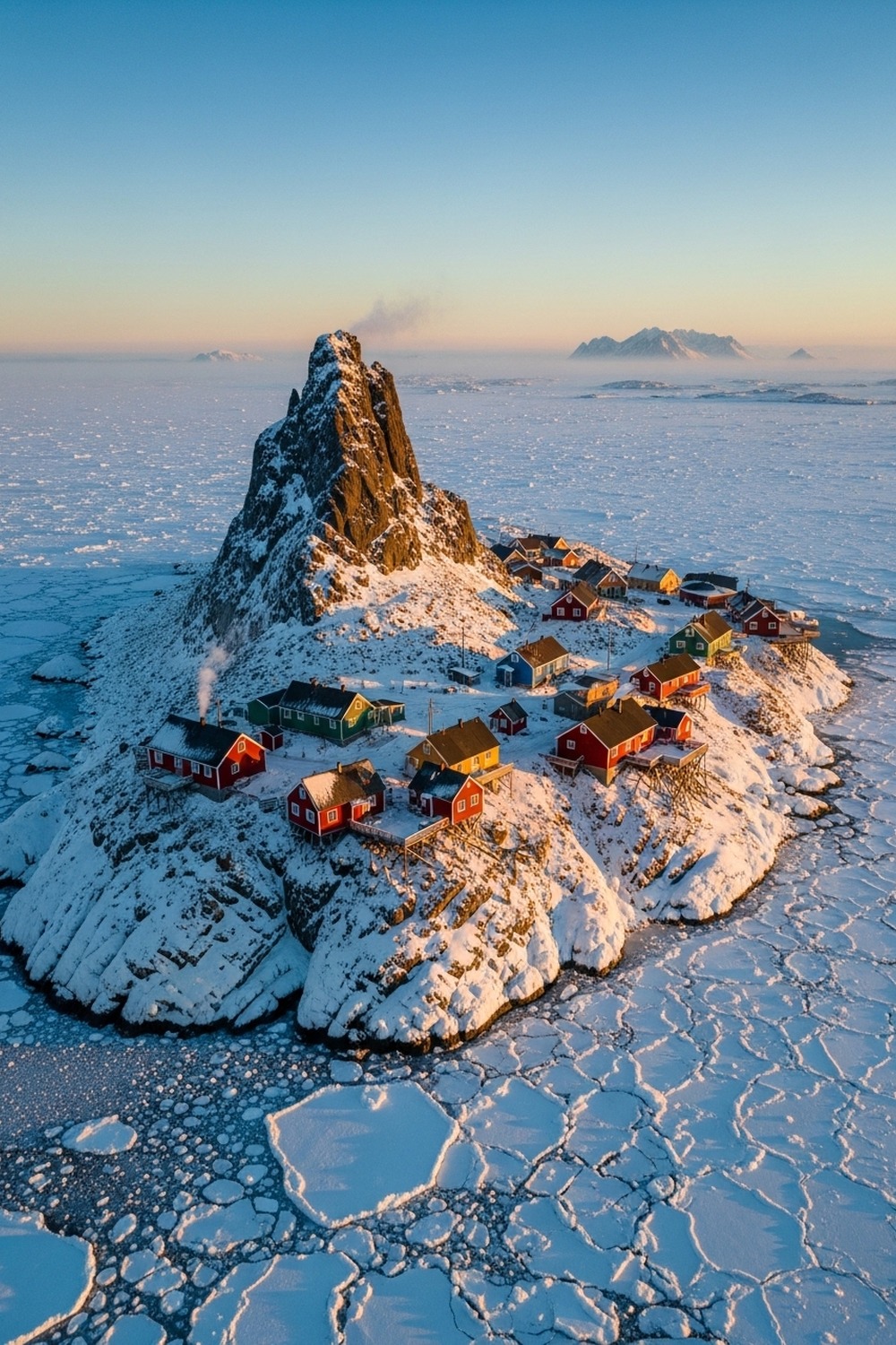
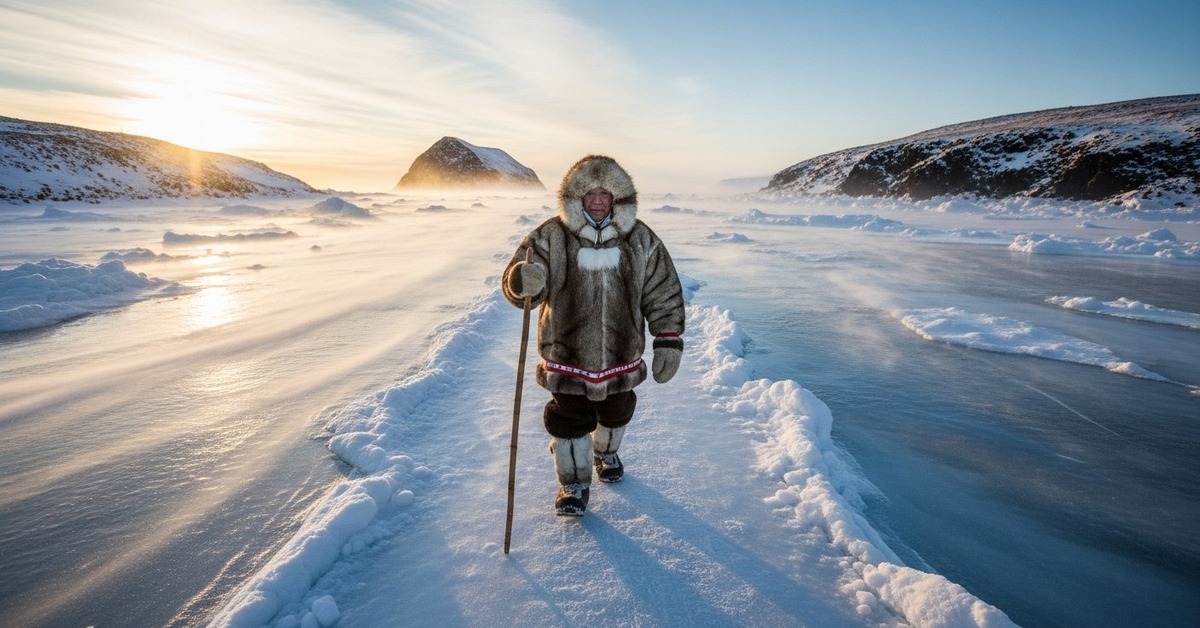
The locals have always called them Yesterday Island and Tomorrow Island. Big Diomede belongs to Russia — no civilians, just a military weather station and the wind. Little Diomede belongs to the United States — roughly 80 Iñupiat people, one school, no road access, and a view that no other community on Earth can claim. On clear days, which are rarer than you’d think, you can read the future from your own front porch. What that does to a person — year after year, generation after generation — is a question worth sitting with.

Where the Date Line Cuts Through Living History
Formalized at the International Meridian Conference in Washington, D.C. in 1884, the International Date Line was never meant to be a human story. It was a cartographic convenience — a way to reconcile the fact that the Earth keeps spinning while clocks don’t. The line roughly follows the 180th meridian, bending around territories and nations to avoid splitting countries into different calendar days. In the Bering Strait, it threads between the two Diomede Islands with almost surgical precision, placing Big Diomede on the Russian side — and the western calendar — while Little Diomede stays anchored to Alaska time. These two islands, separated by 2.4 miles at their closest points, sit 21 hours apart during standard time and 23 hours apart during summer, when daylight saving time widens the gap further.
Before 1884, none of this existed. Every town, every port, every rail depot kept its own solar time — noon was when the sun was highest, and that was that. The standardization of global time zones didn’t just reorganize clocks. It reorganized how humans understood their relationship to place. For the Iñupiat of Little Diomede, a people whose ancestors crossed the Bering Land Bridge long before any cartographer picked up a pen, the notion that a line drawn through water could define when a day begins must have landed as a peculiar kind of colonialism. Not of land. Of time itself.
The two islands are visible to each other year-round, weather permitting. On a clear winter day, Big Diomede’s dark cliffs rise sharply across the grey water. Tomorrow is right there, and it looks exactly like today.
Ice Roads, Iñupiat Memory, and the Walk Between Days
Long before Russia and the United States agreed on anything — long before the 1867 Alaska Purchase handed this corner of the world to Washington for $7.2 million — Iñupiat people walked between the islands freely every winter when the strait froze. They hunted. They traded. They visited family. The ice was a road, not a barrier. For readers who’ve explored how geography shapes human identity, this tension between natural connection and political division echoes stories found across the world’s most remote and extraordinary places. The border that now runs through that ice is not just a line on a map. It’s a rupture in an ancient social fabric.
Why does this matter? Because the Cold War didn’t just militarize the strait — it erased something that had functioned for centuries without anyone’s permission.
During the Cold War, the Soviet Union and the United States effectively sealed the crossing. The U.S. State Department and Soviet authorities classified the Bering Strait as a militarized zone, and for decades, the ice road between Yesterday Island and Tomorrow Island was a crossing no one was permitted to make. Families were split. Contact was severed. When the Soviet Union collapsed in 1991, there was brief, cautious optimism that the crossing might reopen. It didn’t — not officially, not consistently. Visa requirements, bureaucratic obstacles, and lingering geopolitical tension kept the ice empty.
Elders on Little Diomede still remember the names of relatives on the Russian side. Some have never met them. The ice forms every winter the same as it always did. The border holds.
What Living at the Edge of Time Actually Means
Philosophers and physicists alike have wrestled with what time really is — whether it’s a feature of the universe or a human invention layered onto an indifferent cosmos. On Little Diomede, that question isn’t academic. The Smithsonian Institution’s Arctic Studies Center has documented how Indigenous Arctic communities across Alaska and Russia maintain temporal frameworks rooted in seasonal and ecological cycles rather than clock time — the return of the bowhead whale, the angle of winter light, the moment the ice shifts from safe to treacherous. For the Iñupiat of Little Diomede, “time” has always been more about reading the world than reading a dial (researchers actually call this ecological temporality, and it predates written calendars by millennia).
Here’s the thing: what the Diomede Islands International Date Line situation creates is a strange layering that no border commission anticipated. There’s geological time — these islands are remnants of the Bering Land Bridge that connected Asia and North America during the last ice age, exposed as sea levels rose roughly 10,000 to 11,000 years ago. There’s Indigenous time — cyclical, ecological, relational. And then there’s the bureaucratic time of 1884, a line drawn in Washington that declared one island to be Tuesday and the other to be Monday, simultaneously, forever.
Three temporal systems. Same three miles of frozen water. None of them agree with each other.
That’s not a problem to be solved. It’s a condition to be lived.

The Diomede Islands International Date Line and a Warming Strait
A new pressure is reshaping the physical reality faster than any border negotiation could. According to data published by the National Oceanic and Atmospheric Administration (NOAA) in its 2023 Arctic Report Card, the Arctic is warming at approximately four times the global average rate. In the Bering Strait specifically, sea ice extent has declined sharply over the past two decades. In 2018, the Bering Sea experienced its lowest winter sea ice extent on record — a data point that sent researchers from the University of Alaska Fairbanks scrambling to recalibrate their models. The winter ice that once formed reliably enough to land small aircraft on the frozen strait now arrives later, thinner, and less predictably than it did even twenty years ago.
A warming Arctic is not an abstraction for a village of 80 people on a rock with no road access. The community depends on that ice runway for fuel, food, and medical evacuations. When the ice doesn’t form, or forms too thin to bear a Cessna’s weight, Little Diomede is accessible only by helicopter — expensive, weather-dependent, and not always available. Residents already pay some of the steepest fuel prices in the United States. The logistical math of sustaining a community here was always close to the edge. Every degree of warming pushes that edge further.
A community watching its only reliable supply line thin out beneath its feet, while the nearest infrastructure sits three miles away behind a militarized border — that’s not irony. That’s an indictment of every policy conversation that’s failed to treat this place as real.
But the geography makes the silence stranger still. Little Diomede can see Big Diomede. Big Diomede has Russian infrastructure, military resources, supply chains on the other side of that water. Three miles away. Twenty-one hours apart. Completely unreachable by any legal or practical means available to the people who’ve lived there longest.
How It Unfolded
- ~10,000 BCE — Rising sea levels following the last ice age submerged the Bering Land Bridge, isolating the Diomede Islands as distinct landmasses in the strait.
- 1728 — Danish explorer Vitus Bering, sailing for the Russian Empire, became the first European to document the islands, naming them after Saint Diomede on whose feast day they were sighted.
- 1884 — The International Meridian Conference in Washington, D.C. formally established the International Date Line, bisecting the Diomede Islands and placing them in separate calendar days.
- 1991 — Collapse of the Soviet Union briefly raised hopes for reopening Iñupiat crossings between the islands; formal border restrictions have remained largely in place since.
- 2018 — The Bering Sea recorded its lowest winter sea ice extent on record, threatening the ice runway that serves as Little Diomede’s primary supply connection to the mainland.
By the Numbers
- 2.4 miles (3.8 km) — the minimum distance between Little Diomede (USA) and Big Diomede (Russia) at their closest points.
- 21 hours — the time difference between the two islands during standard time, expanding to 23 hours when U.S. daylight saving time is in effect.
- ~80 people — the current Iñupiat population of Little Diomede, making it one of the smallest and most remote communities in the United States.
- 4× — the rate at which the Arctic is warming compared to the global average, per NOAA’s 2023 Arctic Report Card.
- $7.2 million — the price the United States paid Russia for Alaska in 1867, a purchase that drew the border through the Bering Strait and split the Diomede Islands between two nations.
Field Notes
- In 1987, American swimmer Lynne Cox became the first person to swim the Bering Strait, crossing from Little Diomede to Big Diomede in 2 hours and 6 minutes through 38°F (3.3°C) water — a crossing that both the U.S. and Soviet governments quietly endorsed as a symbol of Cold War thaw.
- Big Diomede sits so far west that it shares a time zone with parts of New Zealand — yet it’s geographically in the middle of the Pacific Arctic. Time zones, as drawn, have almost nothing to do with the sun’s actual position from that island.
- Ignaluk — the Iñupiat name for Little Diomede — means “the place that faces.” A name about orientation, about looking outward, about the habit of watching the horizon that defines life there.
- Researchers still can’t definitively determine the precise moment that ancient Iñupiat populations began regularly crossing between the islands. Archaeological evidence from both is incomplete, and Russian access restrictions have limited excavation on Big Diomede since the Soviet era.
Frequently Asked Questions
Q: How exactly does the Diomede Islands International Date Line work — can you really be in two different days at once?
Yes, technically. The International Date Line runs through the Bering Strait between the two islands, meaning Little Diomede (USA) and Big Diomede (Russia) are in different calendar days simultaneously. During standard time, they’re 21 hours apart. Stand on Little Diomede on a Monday and Big Diomede is already Tuesday. The line was established in 1884 and has remained in place ever since, making these islands the most dramatic example of the date line’s real-world consequences.
Q: Can civilians visit Little Diomede or attempt the crossing to Big Diomede?
Little Diomede is a sovereign U.S. village, and visitors can technically travel there — but there’s no hotel, no commercial flight, and no easy way in. Access is by charter helicopter from Nome or, in winter, by small plane landing on sea ice. The crossing to Big Diomede is effectively impossible for civilians. Russian territory, a visa requirement at minimum, no official border crossing point in the strait, and water that is dangerously cold despite appearances.
Q: Do people on Little Diomede experience the date line as strange, or does it become normal?
Most accounts from residents suggest it becomes background reality rather than daily wonder — the same way people near Niagara Falls stop hearing the falls. The more acute strangeness, according to ethnographers who’ve worked with the community, is political rather than temporal: the knowledge that family members, cultural relatives, and ancestral land sit three miles away and remain unreachable. The date line is a curiosity. The border is a wound.
Editor’s Take — Sarah Blake
What stays with me isn’t the date line. It’s the ice runway. A community of 80 people, on a rock in the Bering Strait, dependent on a frozen ocean that’s becoming less frozen every decade — and their nearest neighbor by distance is a Russian military installation they can’t legally approach. The date line makes for a great headline. The actual story is about what happens when the ice that connects you to the world stops showing up on schedule. That’s not a curiosity. That’s a countdown.
Drawn in 1884 by people who were not standing on the Diomede Islands — who were in Washington, D.C., arguing about meridians — the International Date Line has outlasted empires, reshaped families, and now bisects a community watching the ice that sustains it disappear season by season. Somewhere between yesterday and tomorrow, 80 people wake up every morning on a small American rock and look east at the mainland they can’t drive to, and west at the Russian island they can’t visit. What does time even mean, when the practical reality of survival keeps shrinking your horizon?