


Here’s the thing about the Diomede Islands International Date Line: you can stand on a rocky Alaskan beach and watch two different days exist at the same time. Two islands, three miles of frozen water between them, and a gap of 21 hours separating one shore from the other. It shouldn’t be possible to see yesterday from where you’re standing. At the Diomedes, it is.
Little Diomede belongs to the United States. Big Diomede belongs to Russia. Between them runs the International Date Line, an invisible crease in the fabric of global timekeeping that transforms a three-mile stretch of freezing Arctic water into the longest short distance on Earth. About 80 Iñupiat people live on Little Diomede year-round. They look east at tomorrow every single morning. What that does to a person — psychologically, culturally, spiritually — is a question no cartographer has ever thought to ask.


The Line That Splits Yesterday from Tomorrow Island
The International Date Line isn’t a law of nature. It’s a human decision — and a relatively recent one. Before October 1884, every city on Earth kept its own local solar time. Noon meant when the sun was highest overhead, full stop. Railroads broke that system beyond repair — their rapid expansion through the mid-nineteenth century forced governments and scientists to standardize, creating a crisis that local solar time simply couldn’t survive. At the International Meridian Conference in Washington, D.C., delegates from 25 nations agreed to anchor global timekeeping to the Prime Meridian at Greenwich, England — and, by extension, to place its opposite number, the 180th meridian, somewhere in the middle of the Pacific Ocean. The Bering Strait, as it happened, was directly in the way.
The date line doesn’t follow the 180th meridian precisely. It zigzags. It bends around nations and island chains to avoid splitting countries — or communities — in two. The Aleutian Islands pushed it west. Kiribati, in 1995, bent it dramatically east to keep its eastern islands in the same calendar day as its western ones. But in the Bering Strait, the line cuts straight through the water between the two Diomede Islands with surgical indifference. Nobody moved it for the Iñupiat.
The people who’d been crossing that strait for thousands of years simply found themselves, one day, living on opposite sides of an abstraction. The names came naturally after that. Big Diomede: Yesterday Island. Little Diomede: Tomorrow Island. They aren’t officially designated as such on any map. But everyone who knows the strait knows what they mean.
Life on the Edge of the World’s Strangest Boundary
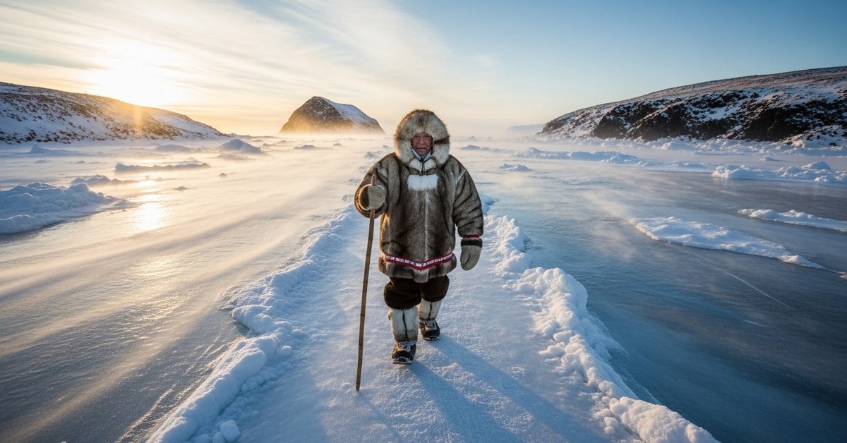
Little Diomede is the kind of place that rewires your sense of normal. There are no roads. There are no docks. The village — officially called Diomede, population hovering around 80, though it fluctuates with the seasons — clings to the face of a steep rocky island that rises sharply from the Bering Sea. Houses stack up the slope like someone forgot to stop building before they hit the cliff. In winter, small planes land on the frozen sea because that’s the only flat surface available. In summer, helicopters ferry supplies. It’s one of the most isolated permanent settlements in the United States, and the residents, members of the Iñupiat people, have chosen to stay there — many of them for generations — because this is their home in a way that has nothing to do with convenience.
For readers drawn to communities that define themselves on their own terms, it’s worth exploring stories of remarkable places where humans have made the improbable ordinary.
Big Diomede, by contrast, holds no permanent civilian residents. Russia has maintained a military weather station there since the Soviet era, and access is strictly controlled. In 1948, the Soviet government forcibly relocated the Iñupiat and Yupik people who had lived on Big Diomede for centuries, scattering a community that had existed continuously for at least 3,000 years. Those families were moved to the Chukotka mainland. Their descendants remain there today, separated from the island by politics, by history, and by a date line that nobody asked them about. The two islands sit roughly 2.4 miles apart at their closest points — sometimes cited as three miles across a longer crossing. On a clear day, the distance feels almost insultingly small.
How Ice Turned a Calendar Into a Road
Every winter, the Bering Strait freezes. The Smithsonian Institution’s Arctic Studies Center has documented the extraordinary continuity of these crossings — Indigenous peoples of the Bering Strait region maintained active exchange networks across the strait for at least 2,000 years, possibly longer, treating the frozen water not as a barrier but as a seasonal road. The ice that forms between Little and Big Diomede has been a highway for Iñupiat people since long before European contact, used for hunting, for trade, for maintaining kinship ties between communities on both sides of what is now an international border. The Diomede Islands International Date Line experience, in this sense, is inseparable from a much deeper story about human mobility and the audacity of living in genuinely hard places.
A line drawn through a worldview that had never organized itself around lines — that’s what the date line actually did here.
What makes the frozen crossing philosophically strange today is what happens when you walk it. Leave Little Diomede heading west, cross three miles of sea ice, and step onto Big Diomede — you’ve moved backward 21 hours in time. Today becomes yesterday beneath your feet. Turn around and make the return trip, and tomorrow arrives before you’ve had dinner. The Iñupiat have a word for this kind of elastic relationship with time, though it’s not a single clean translation — it’s more a cultural orientation toward cyclical time that doesn’t privilege the linear Western model. In winter 2022, journalist Katie Orlinsky documented conditions on Little Diomede for National Geographic, describing a community acutely aware of its geopolitical position — within sight of Russia, within earshot of policy debates they’ve never been invited to join. The ice road between the islands, she noted, still forms every year. Nobody crosses it anymore.

The Diomede Islands International Date Line and the Physics of Human Time
Time zones are political objects dressed up as scientific ones. Little Diomede runs on Alaska Standard Time, which is UTC−9. Big Diomede runs on Magadan Time, UTC+12. The International Bureau of Weights and Measures, based in Sèvres, France, maintains Coordinated Universal Time (UTC) — the global standard against which all those zones are measured. The gap between UTC−9 and UTC+12 is 21 hours — not 24, because the two zones bend toward each other around the globe, leaving a gap just shy of a full day. In summer, when both islands observe daylight saving adjustments, the gap shifts to 23 hours. At certain points of the year, the Diomede Islands International Date Line gap is the largest time difference achievable between two visible points of land anywhere on Earth.
Why does this matter? Because the superlative isn’t just trivia — it’s evidence of how dramatically a political convention can reshape lived reality.
Other places straddle the date line — Samoa and American Samoa are separated by 25 hours and sit about 77 miles apart. National Geographic has documented how Samoa unilaterally moved itself across the date line in 2011 to align its business calendar with Australia and New Zealand rather than the United States, effectively losing a Wednesday in December of that year. The entire country skipped from Thursday the 29th to Saturday the 31st. Date lines, it turns out, are negotiable — you just have to be willing to sacrifice a Wednesday. The Diomede crossing can’t be renegotiated so easily. The line runs through contested geopolitical water, between a NATO-adjacent nation and Russia, across a strait that Cold War planners once described as a potential flashpoint. The calendar gap is the least of the complications.
What It Does to You, Living Inside This Riddle
Isolation isn’t the hardest thing for residents of places like Little Diomede — it’s the invisibility. That finding recurs across decades of research on psychological wellbeing in extreme Arctic communities, including work conducted by the University of Alaska Fairbanks since the 1990s. Decisions made in Washington about border policy, about helicopter contracts, about the price of fuel flown in by plane, land on people who had no seat at the table. The date line is, in this sense, a perfect metaphor for the Iñupiat experience of governance: a line drawn by people who weren’t here, dividing things that didn’t need dividing, carrying consequences that were never the line-drawers’ problem to live with. History has a way of treating the people who drew those lines — and never looked back at what they severed — unkindly.
One elder interviewed by the Alaska Native Language Center in 2009 described the visible proximity of Big Diomede not as a curiosity but as a wound. Families were separated in 1948 when the Soviets cleared the island. For decades, relatives could see each other’s island and not reach each other — not because of the ice or the water, but because of the political system imposed on top of the geography (and this matters more than it sounds: the strait never changed; only the rules about who could cross it did). The Diomede Islands International Date Line is technically a matter of time. Emotionally, for the people there, it’s always been a matter of something harder to name.
And there are roughly 80 people on Little Diomede right now, looking west at an empty island every day. The date line runs between them and it. Yesterday sits three miles away, perfectly visible, completely unreachable.
How It Unfolded
- 1728: Danish explorer Vitus Bering, sailing for Russia, passes through the strait that will bear his name and records the Diomede Islands on August 16th — the feast day of Saint Diomede, giving the islands their name.
- 1884: The International Meridian Conference in Washington, D.C. establishes the Prime Meridian at Greenwich and creates the framework for the International Date Line, placing it — with no consultation of Arctic Indigenous peoples — through the Bering Strait.
- 1948: Soviet authorities forcibly relocate the entire Indigenous population of Big Diomede to the Chukotka mainland, ending thousands of years of continuous habitation and severing family ties across the strait.
- 2011: Samoa moves itself across the International Date Line — skipping December 29th entirely — to align economically with Australia and New Zealand, demonstrating that the line is a political tool, not a fixed fact of nature.
By the Numbers
- 2.4 miles: the minimum distance between Little Diomede (USA) and Big Diomede (Russia) at their closest points
- 21 hours: the time difference between the two islands under standard time conditions (UTC−9 vs. UTC+12)
- 80: approximate permanent population of Little Diomede village, one of the least accessible settlements in the United States
- 3,000+ years: estimated duration of continuous Indigenous habitation in the Diomede Islands region before Soviet forced relocation in 1948
- 25 nations: number of countries represented at the 1884 International Meridian Conference that standardized global time and established the date line framework
Field Notes
- In 1987, Lynne Cox became the first person in modern recorded history to swim across the Bering Strait — completing the 2.7-mile crossing in just over two hours in water that rarely exceeds 38°F. She swam from Little Diomede to Big Diomede, technically arriving in yesterday. Soviet leader Mikhail Gorbachev personally congratulated her, calling the swim a symbol of friendship between the two nations.
- Little Diomede has no natural harbor. Supply boats can’t dock. Everything that arrives on the island — fuel, food, building materials — must be offloaded in open water and carried ashore by small boat or left on the ice in winter. A bag of flour costs roughly five times its mainland price by the time it reaches the village.
- No international treaty has ever fixed the International Date Line in place. It’s maintained by convention, not law — meaning any nation with territory near the 180th meridian can theoretically move it, as Kiribati did in 1995 and Samoa did in 2011.
- Researchers at the University of Alaska Fairbanks still can’t fully answer how the forced 1948 displacement of Big Diomede’s Indigenous population affected oral traditions, language preservation, and cultural continuity — the disruption was abrupt enough, and documented poorly enough, that significant gaps remain in the historical record.
Frequently Asked Questions
Q: What exactly is the time difference created by the Diomede Islands International Date Line?
Under Alaska Standard Time and Magadan Time, Little Diomede (USA) runs at UTC−9 and Big Diomede (Russia) runs at UTC+12 — a difference of 21 hours. In summer, when daylight saving adjustments apply differently to each zone, the gap can reach 23 hours. This makes the Diomedes the most extreme visible time difference between two landmasses anywhere on Earth.
Q: Can you actually cross between the two Diomede Islands today?
Practically speaking, no — not legally, and not easily. Crossing requires navigating an international border between the United States and Russia, which demands formal permissions that are rarely granted to civilians. Historically the Iñupiat crossed the ice freely. Today, both governments treat the strait as a sensitive border zone. The crossing that was once a routine part of daily life has become, for most people, impossible.
Q: Is the International Date Line a fixed geographical boundary?
This is the most common misconception. No international treaty fixes the date line — it’s maintained by convention and can be moved. Kiribati shifted it in 1995 to keep all its islands in the same calendar day. Samoa skipped an entire date in 2011 by jumping across it. Nations near the 180th meridian have the practical power to relocate the date line relative to their territory, which means the 21-hour Diomede gap is a political choice, not a permanent geographical fact.
Editor’s Take — Sarah Blake
What stays with me isn’t the time gap — it’s the 1948 forced relocation. Soviet authorities cleared Big Diomede of its people, and for decades those families could look across three miles of water and see the island where their grandparents were born. The date line gets all the attention because it’s a neat philosophical puzzle. But the real story is about what happens when governments treat geography as something to be arranged, and people as something to be moved around inside it. The Iñupiat didn’t need a calendar lesson. They needed to be left alone.
Both Diomede Islands will still be there tomorrow — which, depending on which shore you’re standing on, might already be today. What the date line reveals, more than anything, is how much of the world’s architecture is human-made and human-maintained — drawn in pencil, not carved in stone. The Iñupiat understood the Bering Strait for thousands of years before anyone thought to divide it. Maybe the more honest question isn’t what it does to a person to live within sight of tomorrow. Maybe it’s what it says about the rest of us that we drew the line in the first place.