


Here’s the thing about snowflakes — the science of how long they stay airborne makes them sound almost stubborn. A single ice crystal, fragile enough to vanish at a touch, can hold its position in a winter storm system for close to 60 minutes. Not drifting lazily downward. Actively negotiating with the atmosphere. That’s not poetic license. That’s what the physics of drag coefficients and vertical updrafts actually produces.
Most of us assume snow simply falls — a clean, vertical drop from cloud to ground. But meteorologists at the National Oceanic and Atmospheric Administration have long understood that winter precipitation behaves in far stranger, more beautiful ways than that. A snowflake’s journey from cloud base to your coat sleeve is less a descent than a slow negotiation between gravity and the sky itself. How does something so small and fragile stay aloft that long — and what happens to it while it waits?

The Hidden Science of How Long Snowflakes Stay Airborne
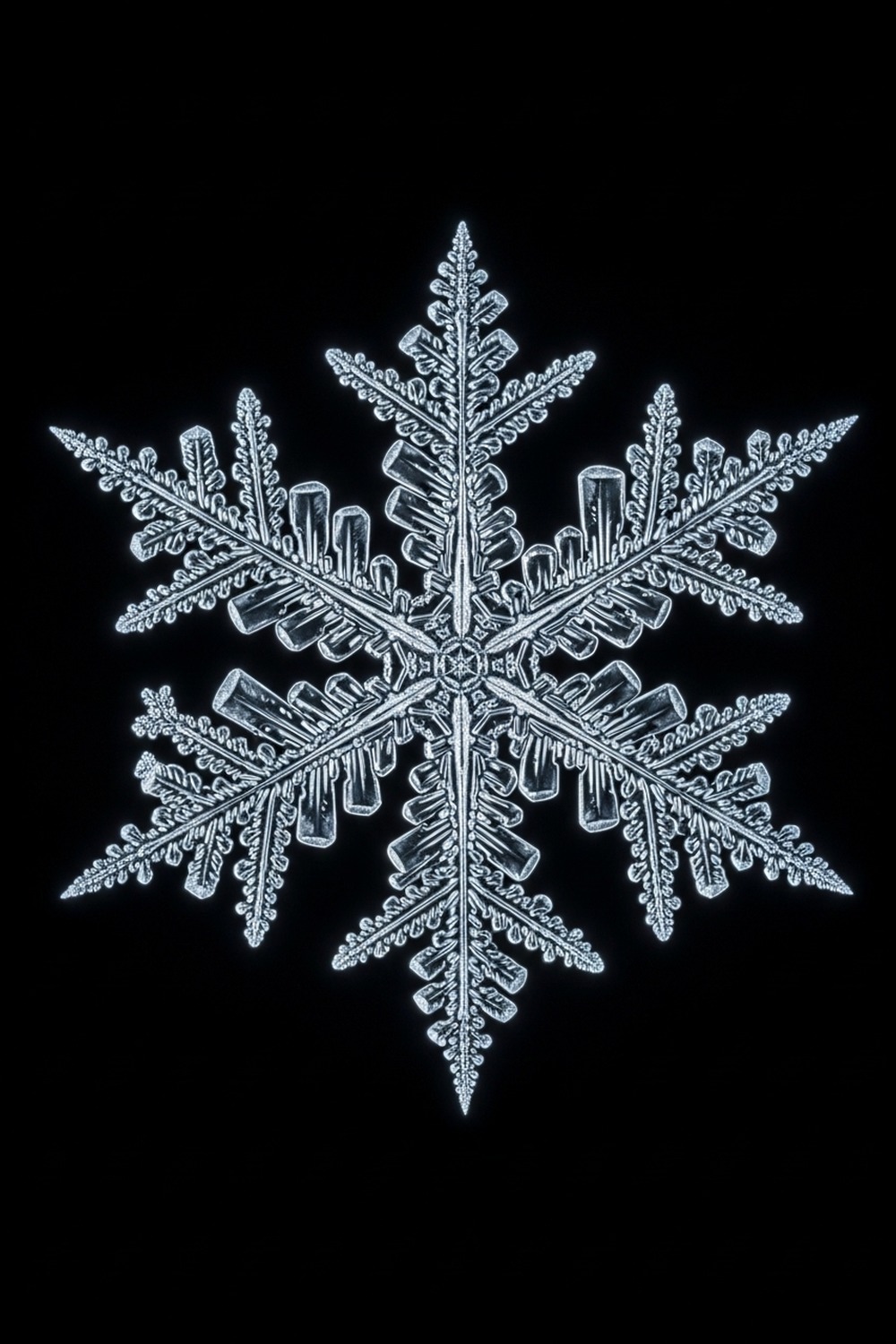
Geometry explains the first part. A classic snowflake — the dendrite form, the one on every holiday card — grows six symmetrical arms radiating outward from a central hexagonal core. Those arms aren’t decorative. They dramatically increase the crystal’s surface area relative to its mass, and that ratio is everything when it comes to how a snowflake interacts with air resistance. According to research by Kenneth Libbrecht at the California Institute of Technology, who has spent decades studying ice crystal formation and behavior, the flat plate-like structure of a falling snowflake creates drag coefficients far higher than a sphere of equivalent mass. That drag — that catching of air — slows a snowflake to terminal velocities as low as 0.5 meters per second under the right conditions.
But low terminal velocity alone doesn’t explain nearly an hour in the air. That requires something else: vertical air movement. Inside a mature winter storm system, updrafts — weak rising columns of air driven by temperature differentials between the storm’s warm core and colder surrounding air — can reach 0.3 to 1.5 meters per second. When a snowflake’s fall speed matches the updraft speed, the crystal achieves something close to suspension. It doesn’t stop entirely. It oscillates, tumbles, drifts horizontally, rises a little, falls a little. It wanders.
Picture it. The cloud base of a winter storm might sit at 2,000 meters above the ground. At an effective descent rate of less than 0.5 meters per second, factoring in repeated updraft interruptions, basic math puts the potential airborne time well beyond 60 minutes. Not every flake takes that path. But some do.
Every Layer of Air Reshapes the Crystal
What makes the long journey genuinely extraordinary isn’t just its duration — it’s what happens to the snowflake during it. Ice crystals aren’t static once they form. As a flake passes through different atmospheric layers, changes in temperature and humidity cause its surface to continue growing, evaporating, and restructuring. A crystal that begins as a simple hexagonal plate in a cloud at −15°C might grow elaborate dendritic arms as it drifts into a zone near −5°C, where branching is thermodynamically favored. This process, documented at length by researchers at the University of Utah’s Department of Atmospheric Sciences, means that a snowflake arriving at the surface may look completely different from its original form. If you’re drawn to the strange and slow-moving forces that shape the natural world, there’s a whole category of phenomena explored across this amazing world that follows that same quiet logic — nature operating by rules most of us never notice.
Temperature governs shape in surprisingly specific ways. Between 0°C and −3°C, ice grows as thin plates. Between −3°C and −8°C, the dominant forms are needles and columns. From −10°C to −22°C, dendrites emerge in their most complex configurations. Below −22°C, plates dominate again. A snowflake falling through 2,000 meters of atmosphere may pass through several of these zones in sequence, accumulating characteristics of each. By 2019, high-speed imaging studies using multi-angle snowflake cameras — instruments deployed at field sites in Vermont and Colorado — had catalogued over 100 distinct morphological categories of natural snow crystals (researchers actually call this a morphological classification diagram), each tied to specific atmospheric temperature-humidity combinations.
Every snowflake arriving on your glove is a frozen record of its own flight path. The branching pattern isn’t just beautiful. It’s a diary. Read the arms carefully enough, and you’re reading the history of the sky.
Wilson Bentley’s 46-Winter Obsession Changed Everything
Wilson Alwyn Bentley was a Vermont farmer, born in 1865 in Jericho, who received a microscope as a teenager and quickly became consumed by snow crystals. In 1885, at age nineteen, he became the first person in history to successfully photograph a single snowflake through a microscope — a technical achievement that required him to catch a flake on a cold black velvet board, transfer it to a glass slide in subfreezing air, and expose a photographic plate fast enough before sublimation erased the detail. He spent the next 46 winters doing exactly that, accumulating nearly 5,000 photographs before his death in 1931. His work is archived at the Smithsonian Institution, and his legacy is explored in depth at Smithsonian Magazine, which describes how his obsessive cataloguing fundamentally changed atmospheric science’s understanding of ice crystal diversity.
Forty-six winters of field work, and Bentley never claimed definitively that no two snowflakes are identical — that conclusion came later, extrapolated from his documentation. Physicist John Hallett at the Desert Research Institute in Reno, Nevada, spent years modeling the combinatorial possibilities of ice crystal formation, estimating in the 1980s that the number of possible dendritic configurations is so astronomically large that the odds of two identical complex snowflakes existing in Earth’s entire history approach zero. How long a snowflake stays in the air directly influences this uniqueness: a longer flight means more atmospheric encounters, more morphological decisions, more divergence from any other crystal’s path.
A simple snowflake — a tiny hexagonal plate with no branching — could theoretically duplicate. Bentley photographed several near-matches early in his career. But the elaborate six-armed dendrites that most people picture? Those are essentially unrepeatable.
How Long a Snowflake Stays in the Air Affects How Snow Accumulates
Why does this matter beyond the lab? Because the airborne duration of individual crystals determines the physical character of the snowpack that entire river systems depend on.
Atmospheric scientists at the National Center for Atmospheric Research (NCAR) in Boulder, Colorado, have studied snowfall accumulation patterns since the 1960s, and their datasets reveal something counterintuitive: snow that travels farther horizontally during descent — as a direct consequence of how long a snowflake stays in the air — creates distinctly different snowpack structures than snow that falls quickly and vertically. Flakes that spend longer aloft tend to partially sublimate at their extremities, losing some of their most delicate branches. They arrive lighter, drier, and less cohesive. The result is the famous “powder snow” of high-altitude regions, prized by skiers and studied by avalanche researchers for its unstable, low-density stacking behavior.
Dense, wet snow tells the opposite story. When temperatures near the surface approach 0°C, the air becomes saturated with moisture, updrafts weaken, and flakes fall quickly and heavily, accreting water on their surfaces. These flakes have spent less time in the air. They’re heavier, stickier, better at building snowmen and worse at staying on steep slopes. The distinction matters enormously for water resource management: the American West depends on snowpack accumulation in the Sierra Nevada and Rocky Mountains, and the density and structure of that pack — influenced in part by how long individual crystals spent airborne — determines how much meltwater will flow into reservoirs in spring. NCAR estimates that roughly 70 percent of freshwater supply in the western United States originates as mountain snowpack.
The data left no room for alternative interpretation — and the water managers who ignored crystal morphology in their snowpack models spent decades explaining forecast errors that the physics had already predicted.
Avalanche forecasters in places like Chamonix, France, and Revelstoke, British Columbia, read new snowfall’s crystal type before issuing warnings. They’re asking, in practical terms: how long did this snow fly? A field of surface hoar — large flat crystals grown slowly over days of still air — creates a buried layer so structurally weak that it collapses under added weight months later. Knowing the crystal’s airborne biography can, quite literally, save lives.


How It Unfolded
- 1885 — Wilson Bentley of Jericho, Vermont, became the first person to successfully photograph a single snow crystal through a microscope, opening the scientific study of snowflake morphology.
- 1931 — Bentley’s collected photographs, numbering nearly 5,000 individual crystals, were published posthumously as Snow Crystals, establishing the first comprehensive visual taxonomy of ice crystal forms.
- 1988 — Physicist John Hallett at the Desert Research Institute published foundational work on the temperature-humidity growth diagram for ice crystals, formalizing the link between atmospheric conditions and crystal shape.
- 2019 — Multi-angle snowflake camera networks deployed across Vermont and Colorado produced the most detailed real-time dataset of falling snow crystal morphology ever recorded, cataloguing over 100 distinct structural categories.
By the Numbers
- ~0.5 m/s — minimum recorded terminal fall velocity of a complex dendritic snowflake under low-turbulence conditions (NCAR, 2017)
- 46 winters — the span of Wilson Bentley’s snowflake photography career, producing 5,000 catalogued individual crystals between 1885 and 1931
- Up to 60 minutes — the estimated maximum airborne duration of a single snowflake in a turbulent winter storm with active updrafts
- 70% — approximate share of freshwater supply in the western United States that originates as mountain snowpack, according to NCAR estimates
- 100+ — distinct morphological categories of natural snow crystals identified in high-speed imaging studies by 2019, each linked to specific temperature-humidity combinations
Field Notes
- In 1988, atmospheric scientist Charles Knight at NCAR became one of the first researchers to document what he called “rimed” snowflakes — crystals that had collected hundreds of tiny supercooled water droplets during their fall, transforming delicate dendritic arms into rounded graupel pellets. The finding confirmed that snowflakes don’t just drift passively — they actively interact with and collect particles throughout their entire airborne journey.
- Turns out a snowflake’s fall isn’t straight. High-speed photography shows that plate crystals oscillate and flutter as they descend, rocking back and forth like falling leaves — which is why snow appears to drift sideways even in nearly calm air.
- Fresh snow can absorb up to 60 percent of sound energy, which is why the world goes unnervingly still during a heavy storm, even in a city. The quietness of heavy snowfall isn’t silence. It’s acoustic absorption.
- Scientists still can’t fully predict exactly what shape a snowflake will take at formation. Kenneth Libbrecht at Caltech can recreate individual crystal types in the lab under controlled conditions, but the precise reasons why branching initiates at specific points — rather than growing as a smooth edge — involves nanoscale ice surface physics that remain incompletely understood as of 2024.
Frequently Asked Questions
Q: How long does a snowflake stay in the air before reaching the ground?
How long a snowflake stays in the air depends primarily on updraft strength and the crystal’s fall speed. In a turbulent winter storm with active rising air currents, a single complex dendrite can remain aloft for close to 60 minutes. Under calmer conditions with no updrafts, most snowflakes reach the ground in 30 to 60 minutes simply based on their low terminal velocity of 0.5 to 1.5 meters per second across a typical cloud-to-ground distance of around 1,000 to 2,000 meters.
Q: Why do snowflakes have six sides?
Six-fold symmetry in snow crystals follows directly from water’s molecular structure. When water molecules freeze into ice, they form hydrogen bonds that arrange themselves into hexagonal lattice structures — six molecules per ring — and that geometry propagates outward as the crystal grows. Every branch, every plate, every arm reflects the same underlying six-fold symmetry because every new ice molecule added to the crystal follows the same molecular bonding rules. Not design. Chemistry expressing itself at every scale.
Q: Is it really true that no two snowflakes are identical?
For simple crystals — small hexagonal plates or needles — duplicates are theoretically possible and have likely occurred. The “no two alike” rule applies specifically to large, complex dendritic snowflakes, where the number of possible structural configurations is so vast that physicist John Hallett estimated the odds of two identical complex crystals existing in Earth’s history as essentially zero. It’s a probabilistic claim, not a physical law. But given how long a snowflake stays in the air and how many independent atmospheric decisions shape its structure, the math strongly supports it.
Editor’s Take — Dr. James Carter
What strikes me most about this story isn’t the 60-minute figure — it’s the implication that every snowflake landing on your sleeve has already lived through a full atmospheric event, been reshaped by it, and arrived carrying a frozen record of conditions you’ll never directly observe. We study climate through ice cores drilled from glaciers, reading ancient atmospheres trapped in layers of compressed snow. The individual flake is the same thing, smaller. A single data point from a storm that will never happen again.
Snowfall is one of the few weather events that genuinely slows people down — that makes them stop, look up, and go quiet. Maybe that instinct is right. What’s drifting down around you isn’t simply precipitation. It’s the visible record of invisible forces, each crystal shaped by a 60-minute journey through layers of sky that no instrument fully maps and no forecast perfectly predicts. How many of those paths have ended unseen, on an empty ridge, or the surface of a frozen lake, in the dark? The sky has been running that experiment, unobserved, for as long as there’s been winter.