


Most people assume a snowflake falls the way a stone does — fast, direct, indifferent to the air around it. That assumption is wrong by nearly an hour. How long does a snowflake stay in the air is a question with an answer that reshapes everything you think you know about a winter storm: up to 60 minutes, across distances that would surprise a meteorologist, through atmospheric layers that keep rewriting the crystal’s shape on the way down.
We treat snow as something that falls — a vertical transaction between cloud and ground. The physics disagree. The turbulent internal architecture of a winter storm and the peculiar geometry of ice crystals make the real journey far stranger. The question worth asking isn’t just how long a snowflake stays aloft. It’s what the flake becomes during all that time — and what that means for what eventually lands.

The Science Behind How Long a Snowflake Stays Aloft
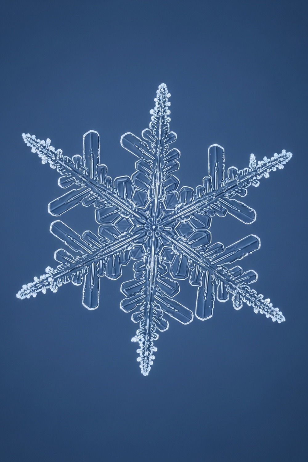
Start with geometry. A snowflake’s signature shape — those wide, flat, six-sided arms reaching outward — isn’t decorative. It’s aerodynamic in the most literal sense. That broad surface area catches air the way a badminton shuttlecock does, creating drag that dramatically slows its descent. Atmospheric physicist Kenneth Libbrecht of the California Institute of Technology has spent decades studying snow crystal formation, documenting in peer-reviewed work how the dendrite arms of a dendritic ice crystal can reach proportions wide enough relative to their mass to make gravity’s work genuinely difficult. In a calm atmosphere, a typical snowflake falls at roughly 1 to 1.5 meters per second — a fraction of the speed of a raindrop, which can hit 9 meters per second.
Clouds that produce snow typically form at altitudes between 1,000 and 6,000 meters above the surface. Do the arithmetic, and even without any assistance from rising air, a flake born near the top of that range could take 70 minutes to arrive.
But the atmosphere isn’t calm. It never is. A winter storm is a three-dimensional machine of rising and falling air columns, and a snowflake is light enough to be caught inside them. Meteorologists have measured weak updrafts inside storm systems reaching speeds of 0.5 to 1 meter per second — almost exactly enough to neutralize a snowflake’s descent rate and hold it suspended. The flake doesn’t hover in one place. It tumbles sideways, drifts horizontally, gets lofted upward and then dropped again in a slow, erratic waltz. That’s how the 60-minute figure accrues: not one long hover, but a repeated cycle of falling and catching.
Think about what that means in spatial terms. A flake drifting horizontally at even a modest 10 kilometers per hour for 45 minutes has traveled 7.5 kilometers from where it was born. The snow falling in your garden may have started its life above the next town over. It arrived as a traveler.
How a Snowflake Keeps Changing Mid-Flight
Why does this matter? Because the flake doesn’t stop growing once it leaves the cloud — it keeps changing throughout its entire descent.
Temperature and humidity vary significantly across different layers of the atmosphere, and as a snowflake passes through each zone, those conditions continue to sculpt it. Here’s the thing: this is one of nature’s more elegant feedback loops — the crystal’s shape determines how long it stays airborne, and its time airborne determines how complex its shape becomes. The atmospheric window between roughly minus 12°C and minus 16°C is where the most elaborate dendrite arms form, according to Libbrecht’s research. A flake passing through this zone slowly — held up by updrafts — has more time to build complexity than one that punches straight through in seconds. If you’re curious about how environmental conditions produce some of the most intricate patterns in the natural world, there’s a broader story at This Amazing World, where the geometry of nature keeps surfacing in unexpected places.
At warmer temperatures closer to 0°C, ice crystal arms begin to sublimate slightly at their tips, rounding edges that were once sharp. Below minus 20°C, growth nearly stops altogether, and the crystal becomes a simpler, more plate-like structure. A single snowflake on a long descent might pass through all of these regimes in sequence, its architecture being written and rewritten by each layer. In 2013, researchers at the University of Utah documented this mid-flight reshaping by tracking ice crystal properties at multiple altitudes within the same storm system simultaneously, finding measurable differences in crystal complexity between 3,000 meters and 500 meters above the surface.
Wilson Bentley of Jericho, Vermont understood something of this intuitively. He began photographing individual snowflakes through a microscope fitted to a bellows camera in 1885, and in 46 winters he captured nearly 5,000 images. He never found two identical ones. He couldn’t have known the atmospheric physics behind it, but he knew the outcome: every flake had lived a different life on the way down.
Wilson Bentley and the 5,000 Faces of a Falling Crystal
Snowflake Bentley — as he came to be known — was a farmer’s son who became one of the most important citizen scientists in American history. His archive of 5,000 photomicrographs, assembled between 1885 and his death in 1931, remains a foundational dataset in snow crystal research. Working alone on his Vermont farm in conditions that required he catch individual flakes on black velvet and sprint to his camera before warmth could destroy them, Bentley operated with a precision that professional atmospheric scientists have since validated and expanded. The Smithsonian Institution, which holds part of his legacy, has described his work as the first systematic visual evidence that snowflake geometry is essentially unique at the macro scale — that no two flakes grown under real atmospheric conditions are identical. To understand why, count the variables: temperature, humidity, air pressure, trace aerosols, altitude, and time — all varying independently across the 60-minute lifespan of a falling crystal, all leaving their mark on the ice.
The theoretical debate about whether two identical snowflakes could ever exist is actually more nuanced than the popular claim suggests. At the level of individual water molecules, every snowflake contains roughly 10¹⁸ molecules of H₂O, and the number of ways those molecules can be arranged while still producing a visually similar hexagonal form is staggeringly large — but not infinite. Mathematically, two simple plate crystals of identical size grown under carefully controlled laboratory conditions might be virtually indistinguishable. The critical phrase is “controlled laboratory conditions.” How long does a snowflake stay in the air in the real atmosphere? Long enough to make controlled conditions impossible.
Bentley died of pneumonia in December 1931, six weeks after walking home through a blizzard. It’s a death that feels almost literary in its fittingness. The man who spent his life watching snow fell victim to it — but left behind a catalog that scientists still reference nearly a century later.
What This Changes About How We Read a Snowstorm
Understanding how long a snowflake stays in the air reframes the entire experience of a winter storm. Most of us perceive snowfall as a relatively simple meteorological event: clouds form, precipitation falls, accumulation begins. Atmospheric researchers at the National Center for Atmospheric Research (NCAR) in Boulder, Colorado have built sophisticated three-dimensional models of winter storm interiors that reveal something far more turbulent. A mature mid-latitude cyclone — the kind responsible for major snowstorms across the northeastern United States, Canada, and northern Europe — contains updraft and downdraft cells operating simultaneously at different horizontal positions within the same storm. A flake born in one cell can drift laterally into another, be lofted upward again, and cycle through multiple descent attempts before finally landing.
NCAR’s 2018 SNOWIE project (Seeded and Natural Orographic Wintertime Clouds — the Idaho Experiment) used aircraft and radar to map these internal storm structures in unprecedented detail, tracking precipitation particle trajectories within real storms. What that data showed was that the horizontal displacement of ice crystals — how far they travel sideways from their point of formation — is routinely underestimated in standard weather models. Some crystals in orographic storms, where wind forces moist air upward over mountain ranges, were tracked traveling more than 20 kilometers horizontally before landing.
The implications for hydrology are real: snowpack distribution across watersheds doesn’t follow the simple topographic models that water managers have historically used. The data left no room for comfortable assumptions — and the gap between those models and physical reality has consequences measured in reservoir levels and drought forecasts. Where the snow lands isn’t just a function of where the storm was. It’s a function of every updraft the flake rode on the way down.
Snow scientists now refer to this as “crystal-scale transport” (and this matters more than it sounds). A snowflake that lands on a particular ski slope, or a specific watershed, or a particular farmer’s field arrived at that location through a process that was anything but random gravity.


How It Unfolded
- 1885 — Wilson Bentley of Jericho, Vermont makes the first successful photomicrograph of a single snowflake, beginning a 46-year documentation project that establishes the visual uniqueness of snow crystals.
- 1931 — Bentley’s collection of 5,000 snowflake photographs is published as Snow Crystals the same year he dies, cementing his status as the founding figure of snow crystal science.
- 2001 — Kenneth Libbrecht of Caltech begins his systematic laboratory program growing snow crystals under controlled conditions, producing the first rigorous temperature-humidity maps of crystal morphology.
- 2018 — NCAR’s SNOWIE project deploys aircraft and dual-polarization radar inside real winter storms over Idaho, generating the most detailed three-dimensional maps of snow crystal transport ever recorded.
By the Numbers
- ~60 minutes — the maximum time a snowflake can remain aloft in a turbulent winter storm, given updraft speeds and typical formation altitudes (NCAR, 2018)
- 1 to 1.5 m/s — average terminal fall speed of a dendritic snowflake in still air, compared to up to 9 m/s for a large raindrop
- 5,000 — individual snowflake photographs taken by Wilson Bentley between 1885 and 1931, none of which showed two identical crystals
- 10¹⁸ — approximate number of water molecules in a single average snowflake, making the combinatorial possibility space for molecular arrangement effectively astronomical
- 20+ km — maximum horizontal displacement of ice crystals recorded during the SNOWIE project in orographic storm systems over Idaho’s Payette Mountains, 2018
Field Notes
- January 1988: atmospheric scientist Nancy Knight of NCAR reported finding two visually identical snow crystals collected from a research aircraft flying through a storm over Wisconsin — the only documented case in scientific literature. Both were hollow columns, among the simplest crystal forms, not the complex dendrites typically associated with uniqueness claims. The finding clarified, rather than overturned, Bentley’s observations.
- Snowflakes don’t fall straight down even in still air. Their flat geometry causes them to oscillate and tumble in a motion called “side-slip,” which increases their effective air resistance and further slows descent — a behavior first mathematically modeled in detail by researchers at Uppsala University in Sweden in 2004.
- Six-fold symmetry in snowflakes isn’t a biological trait or an evolved feature — it’s a direct physical consequence of the hexagonal molecular bond angles in ice Ih, the form of ice that exists at atmospheric pressures. The universe’s chemistry writes the shape.
- Researchers still can’t fully predict what shape a snow crystal will take given specific starting conditions. Libbrecht’s lab at Caltech can grow crystals and observe their forms, but the computational models for predicting crystal shape from first principles remain incomplete as of 2024 — a fundamental unsolved problem in condensed matter physics hiding inside something we think of as ordinary winter weather.
Frequently Asked Questions
Q: How long does a snowflake stay in the air before reaching the ground?
Under typical conditions in a turbulent winter storm, a snowflake can stay in the air for up to 60 minutes from the moment it forms in a cloud to when it lands. At standard formation altitudes of 1,000 to 6,000 meters and a fall speed of roughly 1 to 1.5 meters per second, even without updrafts a high-altitude flake could take over an hour. Updrafts inside storm systems can extend that time further by repeatedly slowing or temporarily reversing the descent.
Q: Why do snowflakes fall so much more slowly than rain?
It comes down to surface area relative to mass. A raindrop is essentially a sphere — compact, dense, and aerodynamically efficient at cutting through air. A dendritic snowflake has wide, flat arms that extend outward in six directions, creating enormous drag relative to its tiny mass. That drag slows its fall dramatically. It’s the same principle that makes a piece of paper fall slower when held flat than when folded into a ball — shape determines resistance, and resistance determines speed.
Q: Is it really true that no two snowflakes are identical?
Turns out the popular claim is mostly correct but needs qualification. Simple snow crystals — small plates, hollow columns, or needles — can be nearly identical under controlled conditions, and Nancy Knight of NCAR documented such a case in 1988. But the complex branching dendrites that most people picture when they think of snowflakes are a different matter entirely. Each arm grows simultaneously yet independently in response to the exact microenvironmental conditions around it during a 30-to-60-minute airborne journey, making macro-scale duplicates statistically impossible in natural atmospheric conditions.
Editor’s Take — Dr. James Carter
What strikes me most isn’t the 60-minute figure itself — it’s what it means for our hydrological models. Water managers in snowpack-dependent regions from the American West to Central Asia are making decisions about reservoir storage and drought risk based on accumulation data that doesn’t fully account for crystal-scale lateral transport. A snowflake that travels 20 kilometers sideways before landing isn’t just a beautiful physics story. It’s a forecasting problem. The prettiest data in atmospheric science turns out to have some of the sharpest practical edges.
Snow has always been shorthand for quiet — for the world slowing down, muffling itself, going still. But the silence of a snowstorm is deceptive. Above your head, the air is crowded with tiny travelers completing journeys that began an hour ago and a dozen kilometers away, each one reshaped by the passage. And when this winter’s first real storm moves in and the light goes flat and the streets go white, look up for a moment before you look down. What’s coming isn’t falling so much as arriving. It’s been on its way for longer than you thought.