The Two Islands 21 Hours Apart You Can See at Once
Here’s the thing about the Diomede Islands International Date Line — it shouldn’t work as a real place. Two islands, three miles of grey Arctic water between them, and a 21-hour gap that makes tomorrow visible from yesterday’s shore. Most invisible lines on Earth stay invisible. This one you can point at.
The Bering Strait has always been a crossing point — for animals, for ice, for the ancestors of nearly every Indigenous person in the Americas. But that narrow channel between Big and Little Diomede carries something extra now: an invisible boundary that slices time itself in half. What nobody can quite answer is what it feels like to live on one side of it, watching the other shore every single day.
The Strangest Border the Date Line Created
The International Date Line, established as a practical consequence of the International Meridian Conference held in Washington, D.C. in 1884, doesn’t follow any natural feature. It’s a political agreement, a cartographic convenience, a solution to the problem of the Earth being round while timekeeping pretended it was flat. For most of its length, the line runs harmlessly through the middle of the Pacific Ocean, bothering nobody. But near the top of the world, it threads between two small islands in the Bering Strait — Big Diomede, belonging to Russia, and Little Diomede, belonging to the United States — and suddenly the abstraction becomes something you can point at.
The date line isn’t just a concept here. It’s that grey stretch of water. It’s the gap between two visible coastlines. What makes the Diomedes genuinely strange is the math: Russia operates on UTC+12, while Alaska observes UTC-9. That’s a 21-hour difference, not a 24-hour one, because the two islands are geographically close enough that they don’t sit at the full longitudinal extreme from each other. It’s not quite yesterday and tomorrow — it’s more unsettling than that. It’s the same morning on both islands, hours apart. The locals call Big Diomede “Tomorrow Island” and Little Diomede “Yesterday Island.” The names aren’t poetic license. They’re functionally accurate.
The date line curves deliberately around the Diomedes. Without that curve, Alaska and Russia would share a calendar date at the tip — a political headache nobody wanted after the U.S. purchased Alaska from Russia in 1867. The line was bent to prevent it. It’s still bent there today.
Iñupiat People Crossed This Ice Long Before Maps Did
Long before any cartographer drew a line through the Bering Strait, the Iñupiat people were crossing it. The two Diomede islands were inhabited by Indigenous communities for at least 3,000 years, according to archaeological research conducted by the University of Alaska Fairbanks, with evidence of continuous occupation and regular inter-island travel. These weren’t sporadic journeys. They were structured, seasonal migrations — for trade, for marriage, for collective hunting of walrus and bowhead whale. The strait froze solid each winter, creating a natural highway across what is now an international boundary. People moved. Communities stayed connected.
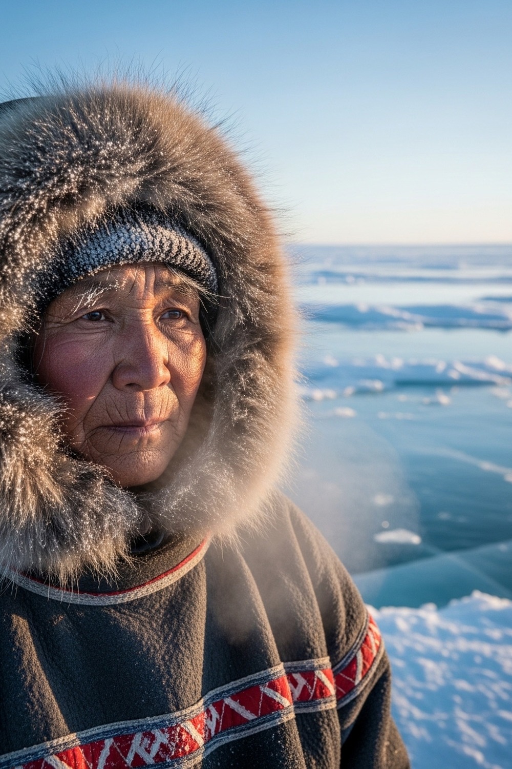
What does it cost to draw a line through a place people have lived for three millennia? The Soviet Union closed Big Diomede to civilians in the 1940s, forcing out its Indigenous Yupik residents and converting the island into a military installation. Families were separated overnight. People who’d crossed that ice their entire lives were suddenly told the crossing was forbidden. For much of the Cold War, the Bering Strait became what journalists called the “Ice Curtain” — a frozen extension of the Iron Curtain, monitored from both sides. The community on Little Diomede, roughly 80 people today, became one of the most isolated in the United States. You can explore more stories of communities shaped by the world’s most unusual borders at This Amazing World.
The ice still forms. Each winter, the frozen strait becomes walkable again. But no one crosses legally now. The border between the two islands is an international boundary — one of the few places in the world where you can see a foreign country clearly and still be completely unable to reach it.
What Living in Sight of Tomorrow Actually Costs
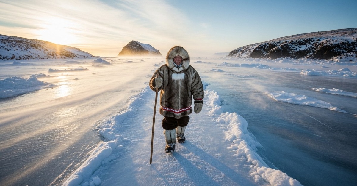
Little Diomede is, by most practical measures, one of the hardest places to live in the United States. There are no roads. There’s no dock. The village clings to a steep hillside on the island’s western face, its houses built close together against wind that regularly exceeds 60 miles per hour. Supply deliveries arrive by helicopter in summer, and by small aircraft landing on the frozen sea in winter — a runway that exists only when temperatures cooperate. According to the Smithsonian Magazine’s reporting on America’s most isolated communities, Little Diomede’s residents endure logistical challenges that most Americans won’t encounter in a lifetime. Food prices run roughly four times the national average. The school, run by the Bering Strait School District, has served as few as four students in recent years.
A place that difficult to reach, that expensive to supply — and people choose to stay. The Diomede Islands International Date Line may be the feature that appears in travel articles, but it’s not what defines life on Little Diomede. What defines it is subsistence — the walrus hunts, the fishing, the community knowledge refined over millennia for this exact environment. The island’s Iñupiat residents are not there despite the isolation. They’re there because the Bering Strait is their home, their pantry, and their inheritance. The date line is just a line. The sea is something else entirely.
In summer, the island sees a small trickle of visitors — researchers, journalists, the occasional adventure traveler. They arrive by charter helicopter from Nome, roughly 135 miles to the east. They all photograph Russia from the shore. Most are there for a day. The residents watch them go.
The Diomede Islands International Date Line in Deeper History
Danish explorer Vitus Bering named both islands on August 16, 1728 — the feast day of St. Diomede in the Orthodox Christian calendar — during his first expedition through the strait that would later bear his name. Bering was sailing for the Russian Imperial Navy, trying to determine whether Asia and North America were connected by land. They weren’t. The strait between them was, at its narrowest point, roughly 55 miles wide. But the two small islands in the middle, separated by only three miles of water, gave the crossing a strange symmetry: a midpoint that was also a boundary. Russia would eventually sell the broader territory to the United States in 1867 for $7.2 million — roughly two cents per acre — and the Diomedes were divided between the two nations in the process.
Alaska, now on the American side of the deal, had previously used the same calendar date as Russia — because it had been Russian territory. After the purchase, Alaska jumped forward in time, skipping 11 days to align with the American calendar. It was October 18, 1867, and then suddenly it was October 6. That kind of temporal violence — imposed from above, absorbed by the people below — is a pattern that repeats throughout the Diomedes’ history. The date line’s position in the Bering Strait has never fundamentally changed since, but the political weight of that gap has shifted dramatically across the decades. Cold War tension turned three miles of Arctic water into one of the most charged distances on Earth. The International Date Line wasn’t formalized until the 1884 Meridian Conference, but its implications rippled outward for years.
Today Big Diomede operates as a Russian weather monitoring station with no permanent civilian population. Little Diomede’s community persists — smaller than it was, but still there, still hunting, still watching the Russian island from their shore as they always have. The date line between them is unchanged. The 21-hour gap remains.
How It Unfolded
- 1728 — Danish explorer Vitus Bering sails through the strait on August 16, naming the two islands after the feast day of St. Diomede, the first known European documentation of the islands.
- 1867 — The United States purchases Alaska from Russia for $7.2 million; the Diomede Islands are divided between the two nations, and Alaska’s calendar is reset by 11 days to align with American timekeeping.
- 1884 — The International Meridian Conference in Washington, D.C. formalizes the International Date Line, cementing the 21-hour time gap between Big and Little Diomede.
- 1948 — The Soviet Union removes all Indigenous Yupik civilians from Big Diomede, converting it to a military installation and severing cross-strait family ties that had existed for thousands of years.
By the Numbers
- 2.4 miles (3.8 km) — the approximate distance between Big Diomede and Little Diomede at their closest points across the Bering Strait.
- 21 hours — the time difference between the two islands, despite their near-identical longitude, due to the International Date Line and the Russia/U.S. time zone boundary.
- ~80 people — current estimated population of the Iñupiat community on Little Diomede, down from historical highs of several hundred.
- $7.2 million — the price paid by the United States for Alaska (including the Diomedes) in 1867, equivalent to roughly $150 million in 2024 dollars.
- 3,000+ years — minimum estimated period of continuous Indigenous habitation on the Diomede Islands, based on University of Alaska Fairbanks archaeological studies.
Field Notes
- In 1987, American swimmer Lynne Cox completed a 2.7-mile open-water crossing from Little Diomede to Big Diomede in 2 hours and 6 minutes, swimming through water just above freezing — a crossing that was partly credited with warming U.S.-Soviet relations and was personally acknowledged by both Ronald Reagan and Mikhail Gorbachev at a summit that year.
- Little Diomede has no natural harbor, which means supply helicopters must hover while goods are offloaded by hand onto the rocks — a logistical reality that makes every delivered item genuinely expensive.
- The International Date Line doesn’t follow the 180th meridian exactly; it deviates significantly around the Aleutian Islands, Kiribati, and the Diomedes specifically to avoid splitting countries and island chains across two calendar days.
- Behavioral geographers (researchers who study how geography shapes psychology) have only begun to seriously document what it does to a community to live within permanent sight of an inaccessible foreign territory — and the Diomedes are among their most unusual case studies.
Frequently Asked Questions
Q: How exactly does the Diomede Islands International Date Line create a 21-hour gap instead of a full 24 hours?
Turns out the gap comes from the specific time zones assigned to each island, not their raw geographic distance. Russia’s Big Diomede operates on UTC+12, while Alaska’s Little Diomede uses UTC-9. That’s a 21-hour difference moving west to east. Cross in the other direction — east to west — and you’d jump forward 3 hours. The date line makes the gap feel more dramatic than the pure math, because crossing it also means changing the calendar date.
Q: Can you actually visit Little Diomede as a tourist?
Technically yes, though it requires significant effort and expense. There are no commercial flights to Little Diomede. Most visitors charter a helicopter from Nome, Alaska — roughly 135 miles to the southeast — at substantial cost. The village is sovereign Iñupiat territory and receives very few outside visitors annually. No hotel, no infrastructure for tourism, no formal welcome program. Some researchers and journalists have made the trip, but it’s not a casual destination by any measure.
Q: What do people most commonly get wrong about the International Date Line and the Diomede Islands?
The most common misconception is that the two islands are exactly one day apart — 24 hours. They’re not. The actual gap is 21 hours, which makes the relationship stranger and more specific than the “yesterday and tomorrow” shorthand implies. And the date line itself is entirely artificial — a political decision made in 1884 — deliberately bent around the Diomedes to prevent Alaska and Russia from sharing a calendar date after the 1867 territorial sale.
Editor’s Take — Sarah Blake
What stays with me isn’t the date line. It’s the 1948 evacuation — Soviet authorities removing an entire Indigenous community from Big Diomede overnight, turning a living village into a military outpost, and leaving the people on Little Diomede to watch an island they’d always known go silent across three miles of water. History has a way of treating the people who ignored this kind of evidence unkindly. The time gap between the islands gets all the attention. But the human gap — the families separated by a political decision, visible to each other and permanently out of reach — is the story that actually deserves to be told.
The Diomede Islands International Date Line is one of those facts that sounds like a riddle until you stand at the water’s edge and realize it’s completely literal. But the real weight of that strait isn’t temporal — it’s human. Somewhere in the 20th century, a line through the water stopped being a curiosity and became a wall. The ice still forms every winter. The crossing is still physically possible. What’s changed is everything around it. And somewhere on Little Diomede, someone is looking east at an island that used to be a neighbor, watching the same grey water they’ve always watched, waiting for nothing in particular to change.