The Roman Mosaic That Recorded an Earthquake in Stone
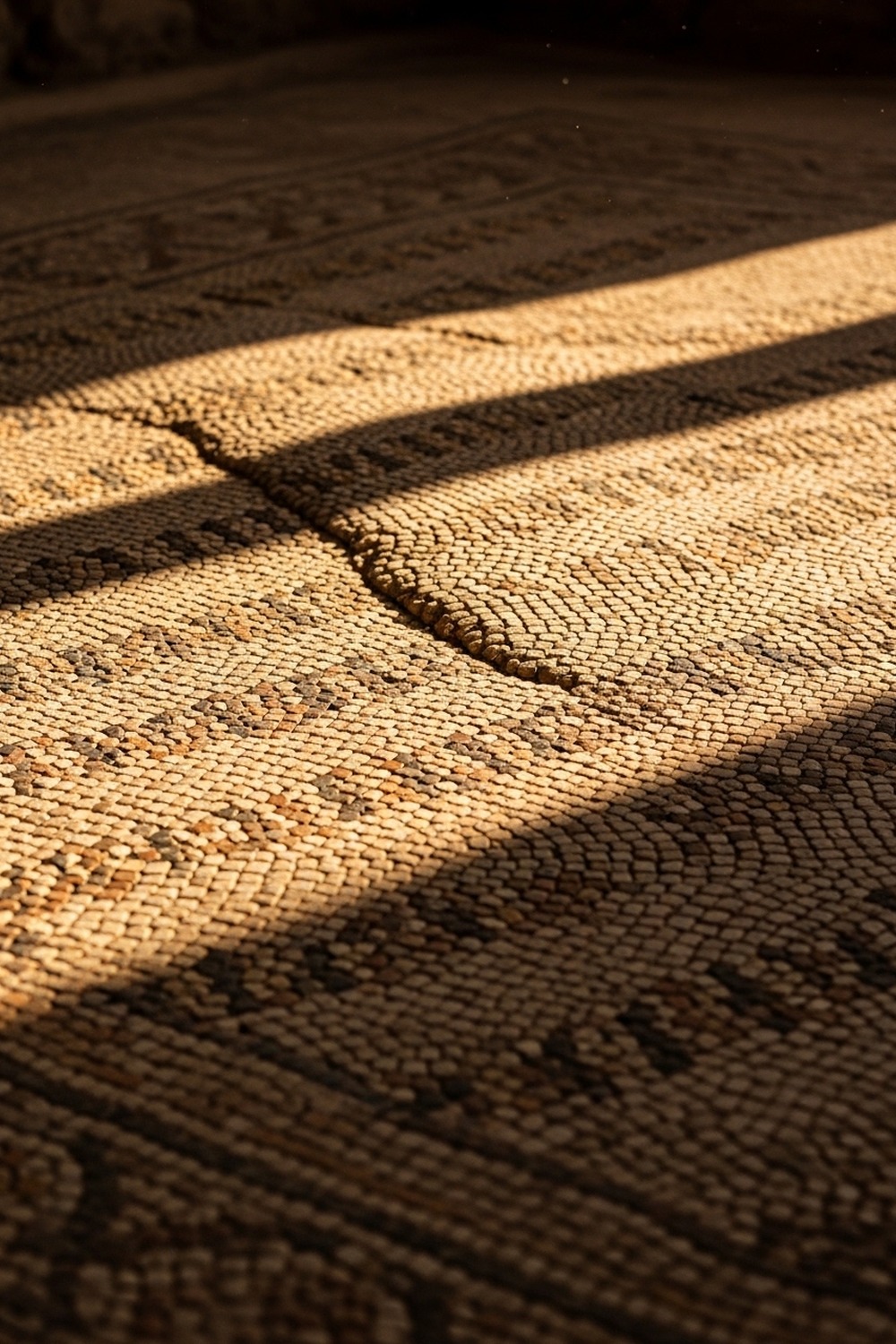
Something rippled through a Roman mosaic earthquake record buried beneath western Turkey — and for decades, nobody called it what it was. The floor moved. The stones held. And the wave it preserved, two to four centimeters at its peak, has been waiting nearly two millennia for archaeologists to ask the right question.
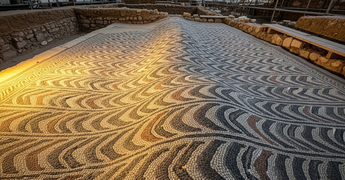
Along Turkey’s seismically restless western coast, archaeologists uncovered a grand villa floor — thousands of tesserae still vivid in red, black, and ivory — carrying a wave across its surface that no Roman artisan had deliberately placed there. The question wasn’t whether the floor had moved. It was what had moved it, and whether anyone had understood what they were looking at until now.
How a Roman Mosaic Became an Earthquake Record
The site sits within what was once the Roman province of Asia Minor — a region the ancient world knew for its wealth, its marble, and its instability underfoot. The North Anatolian Fault, one of the most seismically active strike-slip faults on Earth, runs roughly east to west across northern Turkey and has generated some of the deadliest earthquakes in recorded history, including the catastrophic 1999 İzmit earthquake that killed more than 17,000 people. Researchers analyzing deformation patterns in the mosaic floor — a project formalized through collaborations between Turkish university archaeology departments and structural geologists beginning in the early 2010s — found that the ripple’s directional axis matched the fault’s orientation almost exactly. That alignment wasn’t coincidence. It was confirmation.
Step back from the floor and the geometric pattern looks perfect. Step closer — or run a laser scanner across it — and the deviation becomes undeniable. A wave, perhaps two to four centimeters at its peak deflection, traveling across a surface that otherwise meets Roman standards of geometric precision. Ancient craft, accidentally turned seismograph.
The floor itself contained thousands of individual tesserae, cut from marble, limestone, and colored glass, set into a mortar bed resting on layered sand and crushed lime. This wasn’t a single rigid slab. It was a laminated system — each layer with a different flex response. When the ground moved, the floor moved with it the way a flag moves in wind: as a continuous surface rather than a shattered object. That’s why it didn’t crack. That’s why it rippled. The stones held each other in tension even as the earth beneath them rolled.
The Engineering Rome Built Without Naming It
Roman builders weren’t seismologists. They didn’t have a word for tectonic plates or fault lines. But the ancient world’s most earthquake-prone regions — Anatolia, the Bay of Naples, the Greek islands — produced builders who understood, through generations of hard-won experience, that rigid structures failed while flexible ones survived. The layered foundation system used beneath this villa floor represents exactly that kind of embodied engineering knowledge. It’s the same philosophy that produced the flexible concrete of the Pantheon’s dome and the articulated arch systems of Roman aqueducts. This pattern of geological storytelling encoded in ancient structures connects to a broader history of how civilizations recorded natural events — the way that extraordinary natural phenomena left their marks not just in written records but in the built environment itself.
Here’s the thing: the foundation sequence reads almost like a recipe for survival. Builders started with a compacted earth base, then added a thick layer of clean river sand — typically 15 to 20 centimeters — which acted as the critical slip plane. Above that, a rough mortar layer called the rudus, then a finer setting bed called the nucleus, and finally the tesserae themselves, tapped into fresh lime mortar. The Roman architect Vitruvius documented this sequence in his first-century BCE treatise De Architectura, which remains one of the most detailed surviving records of Roman construction practice. The sand layer is the key. It doesn’t bind. It absorbs. When seismic energy moves through it, the sand grains rearrange — and the whole floor rides the wave rather than resisting it.
Archaeologists who excavate Roman floors regularly note that the ones built over sandy substrates survive seismic events far better than those poured directly onto rock or fired-clay foundations. The difference, when you’re standing in a trench looking at the evidence, is startling. One floor is rubble. The other is a wave. Same earthquake. Different ground beneath.
Reading the Stone the Way Geologists Read Ice Cores
What changed? Everything, once researchers stopped treating the deformation as damage.
The comparison that keeps surfacing among researchers is quiet but powerful: this floor functions like a natural archive, the way ice cores record atmospheric history or tree rings record drought. Geology has long understood that the Earth writes its own biography in layered materials — varves in lakebeds, growth patterns in stalagmites, stress fractures in bedrock. What makes the Roman mosaic earthquake record unusual is that it’s a human-made material accidentally co-opted into that archive. Researchers at institutions including the German Archaeological Institute — which has maintained long-term excavation programs across Turkey and the broader Mediterranean — have begun approaching mosaic deformation analysis as a legitimate subdiscipline (researchers actually call this archaeoseismology), one that can date seismic events to within decades when combined with numismatic and ceramic evidence from the same occupation layer. A Smithsonian Magazine investigation into Roman seismic resilience noted that the ancient Mediterranean world experienced dozens of significant earthquakes per century, many of which went unrecorded in texts but left clear signatures in excavated structures.
A cracked or collapsed floor tells you something broke. A rippled floor tells you something moved — and it tells you how. The vector of displacement, the amplitude of the wave, and the consistency of the deformation across the surface all carry seismological information. Researchers can work backward from the geometry of the ripple to estimate the magnitude and direction of the seismic event. It’s not as precise as a modern seismometer. But for events that happened 1,800 years ago, it’s the closest thing to a reading we’re likely to get.
What’s counterintuitive about this Roman mosaic earthquake record is that the floor’s survival is actually what makes the data legible. Sites previously dismissed as exhibiting simple structural decay are now being re-examined through this lens. The question archaeologists are asking in the field has shifted: not just what happened to this building, but what the building itself recorded while it was happening.
History has a way of treating the people who misclassified this kind of evidence unkindly — because every floor relaid or dismissed as “normal settling” took an irreplaceable seismic record with it.
What Pottery, Coins, and Painted Plaster Add to the Picture
The mosaic doesn’t exist in isolation. Around the floor, excavators recovered a layered assemblage of material culture that helps pin the seismic event — or events — to a historical window. Pottery fragments from the site match ceramic typologies common in western Anatolia between the second and fourth centuries CE, a period of intense Roman building activity in the region following major imperial investment under emperors including Hadrian, who toured Asia Minor in 123–124 CE and reportedly funded reconstruction projects in earthquake-damaged cities. Coins recovered from sealed contexts beneath fallen wall plaster suggest the villa was occupied into at least the late third century. Painted wall fragments, some still preserving traces of red ochre and Egyptian blue — a pigment that requires substantial wealth to source and apply — indicate this was a household of considerable means. A family wealthy enough to commission a mosaic floor of this quality was also wealthy enough to rebuild after disaster, which raises a possibility the evidence seems to support: the floor may have been deformed not once but across multiple seismic events, each adding marginally to the ripple’s amplitude.
And the timing matters. Seismologists working in the region have documented a recurring pattern of earthquake clustering along the North Anatolian Fault. Major rupture sequences don’t happen in isolation — they trigger stress transfer along adjacent fault segments, producing sequences of significant earthquakes over decades. The period between 180 CE and 365 CE was particularly active across the eastern Mediterranean, with historical sources including the historian Ammianus Marcellinus describing catastrophic events in Anatolia during the fourth century. If the villa floor absorbed two or three discrete seismic events during that window, the cumulative deformation could produce exactly the kind of compound ripple researchers are observing.
Some fragments of the painted plaster still show traces of figural painting — a hand, possibly part of a robe. People lived inside these walls. They walked across this floor on ordinary days and on days the ground moved. The floor held both kinds of memory without distinguishing between them.
How It Unfolded
- Second century CE — Roman villa constructed in western Anatolia, floor laid using the layered Vitruvian foundation system that would prove critical to its survival and its story.
- Late third to fourth century CE — One or more seismic events along a branch of the North Anatolian Fault system deform the floor, producing the ripple pattern now visible in excavation.
- Early 2010s — Turkish university archaeologists and structural geologists begin formal analysis of mosaic deformation as a method for reconstructing historical seismicity in the region.
- Present — The site joins a growing body of Roman-period structures being reanalyzed as accidental seismic archives, reshaping how archaeologists and geologists collaborate on Mediterranean fieldwork.
By the Numbers
- 2–4 cm — estimated peak deflection amplitude of the seismic ripple across the mosaic surface, measured by laser scanning analysis.
- 17,000+ — lives lost in the 1999 İzmit earthquake along the North Anatolian Fault, illustrating the fault system’s continued destructive capacity (USGS, 1999).
- 15–20 cm — typical thickness of the sand absorption layer in Vitruvian-standard Roman mosaic foundations, the key element that allowed the floor to flex without fracturing.
- 180–365 CE — approximate seismically active window in the eastern Mediterranean during which the villa’s deformation events most likely occurred, based on coin and ceramic dating.
- Dozens per century — rate of significant earthquakes across the ancient Mediterranean world during the Roman Imperial period, most unrecorded in texts but potentially legible in surviving structures (Smithsonian, 2022).
Field Notes
- Egyptian blue — the pigment found in fragments of painted wall plaster at the site — was one of the ancient world’s most expensive synthetic colorants, manufactured through a complex high-temperature process combining silica, copper, and calcium. Its presence identifies this villa’s owners as members of a genuinely wealthy household, not simply comfortable Romans.
- North Anatolian Fault mechanics closely resemble California’s San Andreas in their strike-slip behavior, meaning horizontal motion — not just vertical — dominates rupture patterns. That horizontal sliding is precisely what produces wave-like deformation in flexible floor systems rather than the clean shear fractures caused by vertical thrust faults.
- Vitruvius described the ideal mosaic foundation in De Architectura Book VII, written around 27 BCE — meaning the layered system that accidentally preserved the seismic record was already considered standard practice a century before this villa was built. The builders weren’t innovating. They were following a manual.
- Researchers still can’t determine conclusively whether the ripple represents one seismic event or several accumulated over decades. The geometry of the deformation is consistent with both interpretations, and without a more precise dating method for the mortar’s post-deposition crystallization, the question may remain open.
Frequently Asked Questions
Q: What exactly makes this a Roman mosaic earthquake record rather than just normal settling?
Normal foundation settling produces irregular, asymmetrical deformation — low spots where material has compressed, random cracks along stress lines. This floor’s deformation is directional and consistent across its full width, with a measurable vector that aligns with the known orientation of a nearby fault segment. That alignment, confirmed through laser scanning and compared against regional seismic mapping, rules out settling as the cause. It’s the directionality that makes it diagnostic.
Q: Could the Romans have intentionally designed the floor to be flexible, or was that a side effect?
Both, in a sense. Roman builders used the layered sand-and-mortar foundation system primarily because it produced a level, stable surface — the sand base compensated for uneven subsoil and distributed load evenly across the tesserae. Seismic flexibility was a functional bonus rather than an explicit design goal. But in earthquake-prone regions like western Anatolia, builders who used rigid poured foundations consistently lost their floors. The ones who survived long enough to build again kept using the sand layer. It’s empirical knowledge encoded in practice before the theory existed to explain it.
Q: Are there other Roman sites where mosaic floors have recorded seismic events the same way?
Researchers suspect yes, but the field of archaeoseismology — using damaged or deformed structures to reconstruct historical earthquake chronologies — is still developing systematic methods for mosaic analysis specifically. Sites in Italy, Greece, and the Levant have all produced floors with anomalous deformation patterns. What’s changing now is the analytical framework: rather than attributing such patterns to poor workmanship or simple age, archaeologists are beginning to document deformation vectors and compare them against regional fault maps. The Roman mosaic earthquake record in Turkey may be one of the clearest examples, but it’s unlikely to be the only one.
Editor’s Take — Sarah Blake
What strikes me most isn’t the seismology. It’s the timeline of ignorance. This floor has been visible — rippled, readable, right there — and for decades the deformation was catalogued as damage rather than data. That’s the uncomfortable part. How many other floors have been relaid, restored, or simply dismissed while carrying seismic records no one had the framework to recognize? The methodology came late. The evidence didn’t wait. Some of what we’ve already excavated may be gone in the one way that matters most: misclassified and reburied.
Turns out the ancient world left us more than libraries, laws, and roads. It left us floors — and some of those floors were listening to the Earth in ways their builders never intended and their excavators took centuries to understand. Somewhere beneath a field in western Turkey, beneath modern roads and olive groves and unremarkable soil, other villa floors may be holding similar records — waves frozen in marble, waiting for the right question. The ground moves. Sometimes, if the foundation is right and the luck holds, the stone remembers.