The Roman Mosaic That Recorded an Earthquake in Stone
Here’s the thing about earthquakes — they don’t always announce themselves with rubble. Sometimes they leave a ripple. The Roman mosaic earthquake record now documented beneath modern Turkey is exactly that: thousands of marble tesserae, still intact, still geometric, bent into a wave pattern that no craftsman arranged. The ground moved. The floor remembered. And for roughly eighteen centuries, everyone who studied it was looking at the wrong thing.
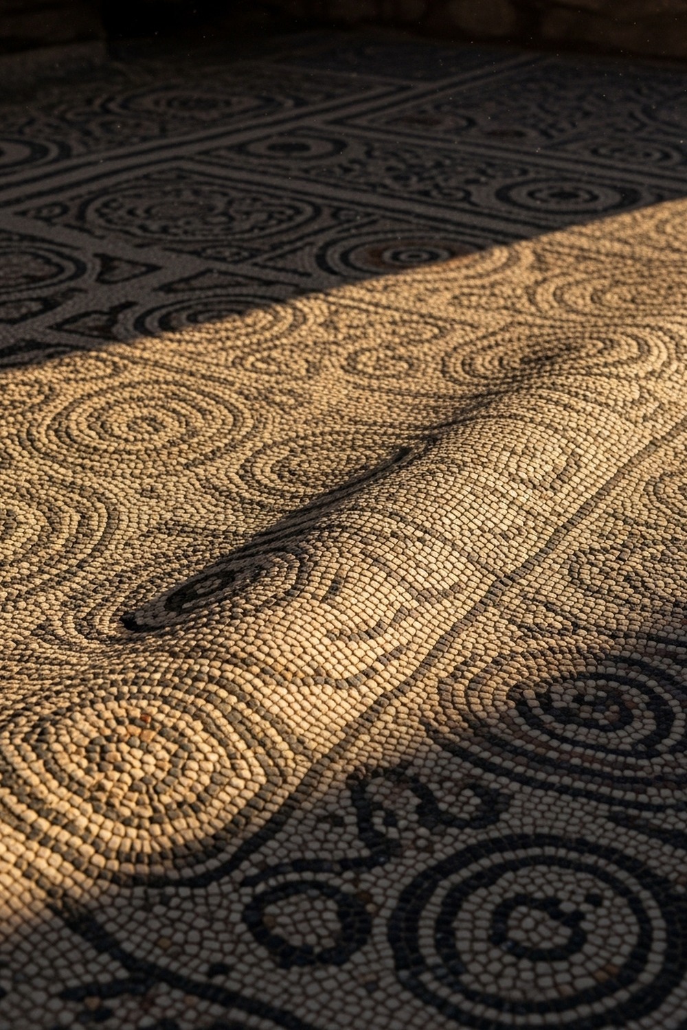
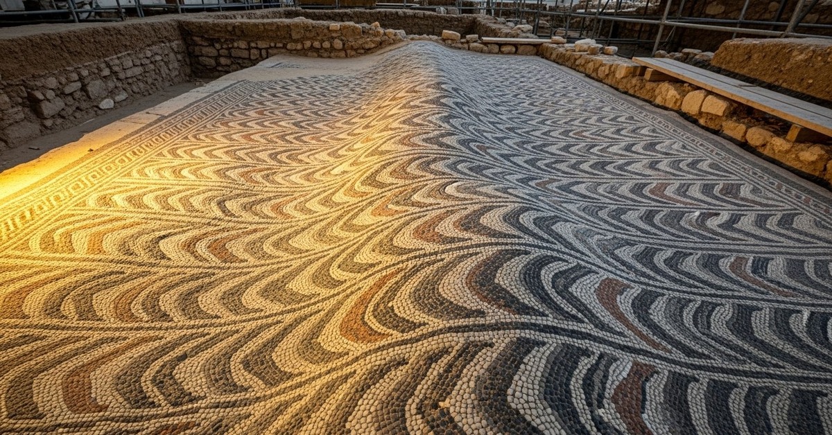
Archaeologists excavating a grand villa floor in ancient Asia Minor weren’t expecting to find seismic data. The mosaic wasn’t shattered. Nothing had collapsed on top of it. It lay vivid and precise, almost defiant in its preservation. But something moved across its surface — a subtle, directional wave — and when researchers aligned that wave against regional fault data, the match was exact.
How Roman Engineers Built a Seismic Canvas
Roman builders working across Asia Minor in the 1st and 2nd centuries CE weren’t simply laying decorative floors. They were solving an engineering problem they understood intuitively, even if they lacked the vocabulary of plate tectonics to describe it. The region sits directly above the North Anatolian Fault, one of the most seismically active strike-slip fault systems on Earth, responsible for earthquakes measuring magnitude 7.0 and above as recently as 1999. Roman architects responded to this reality not with rigidity but with deliberate flexibility. The foundation system used beneath large mosaic floors — called a nucleus in Latin construction manuals — consisted of three or four distinct layers: compacted rubble at the base, then coarse sand, then fine mortar, and finally a lime-based setting bed into which the tesserae were pressed. Each layer had a different density. Each responded to seismic energy differently. Together, they functioned less like a fixed surface and more like a slow-moving membrane.
That layered approach is what makes the survival of this mosaic so striking. It didn’t survive despite the earthquake. It survived because of the engineering designed to accommodate ground movement. When the fault beneath it slipped — and the evidence suggests it may have slipped more than once over the floor’s operational lifetime — the tesserae moved together rather than apart. Researchers examining the ripple pattern found that the deformation follows a directional axis consistent with the fault’s northeast-southwest orientation. The stones didn’t scatter. They undulated. The setting bed flexed, the mortar absorbed the wave, and the surface recorded it the way a pond records a stone dropped at its edge.
An earthquake powerful enough to ripple stone was not powerful enough to break this floor. The Roman solution wasn’t to build harder. It was to build smarter. That distinction still matters.
Reading the Earth Through Roman Geometry
Mosaic floors are studied by art historians, by classicists, by conservators — specialists trained to read symbolism and iconography, not seismic deformation vectors. That’s a reasonable division of labor. It’s also, turns out, the reason this particular story took so long to surface. The Roman mosaic earthquake record hidden in this villa’s geometry required a genuinely cross-disciplinary eye: someone willing to treat an ancient decorative surface as geological data. That intersection of disciplines is rarer than it should be, and the floor itself is a perfect example — catalogued, photographed, and partially restored decades before anyone thought to measure its deformation axis against fault-line orientation data. Some of the most unexpected stories in the natural world emerge precisely when disciplines collide, a theme explored across the range of earth science and historical research featured at this amazing world of discovery.
Because the original geometric pattern — likely a meander or guilloche design common to Roman Asia Minor between 100 and 250 CE — repeats with near-mathematical precision across the floor’s full surface, any deviation registers immediately. Each tessera measures between 8 and 12 millimeters across (researchers actually call this the “diagnostic range” for deformation mapping). Every one was placed by hand. If the original pattern had been irregular, the ripple would disappear into the noise. The earthquake essentially revealed itself against the regularity of human craft.
Pottery sherds recovered from the same excavation layer include red-slip Sigillata ware, datable to the late 2nd century CE. Coins found nearby carry the profile of Emperor Septimius Severus, who ruled from 193 to 211 CE. People walked on this floor. The ground moved beneath it. The stones remember.
What the Ripple Tells Us About Ancient Seismicity
Why does this matter? Because written earthquake records are incomplete by design — biased toward urban centers, imprecise about timing, and silent on events that struck rural zones with no one literate nearby to document them. Physical proxies offer something different. Archaeoseismology, the study of earthquake evidence preserved in archaeological structures, has grown significantly since the 1990s, when researchers began systematically cataloguing fault-related deformation in excavated buildings across the Mediterranean. According to research published by the Smithsonian Magazine, ancient structures across Turkey, Greece, and the Levant have yielded evidence of seismic events that no written source recorded — events that, had they occurred in modern cities, would have triggered major disaster responses. The Roman mosaic earthquake record in Asia Minor belongs to this growing catalogue of silent witnesses. It doesn’t tell us the magnitude or the exact date. But it confirms that the ground moved, in a direction the fault dictated, at some point during the floor’s occupation.
What makes this particular record unusual isn’t just the deformation — it’s the preservation quality. Most mosaic floors that experience seismic disruption show one of two outcomes: they crack along fault-parallel lines and are repaired with visible grout fills, or they’re abandoned and buried when the damage renders the room unusable. This floor shows neither. There are no repair fills. The Roman mosaic earthquake record here appears to be a single, clean, unrepaired deformation event — which suggests either that the occupants didn’t notice the ripple, which seems unlikely, or that they recognized the surface as functionally sound and chose not to interfere with it.
History has a way of treating the people who ignored this kind of evidence unkindly — but whoever decided not to repair this floor made exactly the right call, and the floor is still here to prove it.
The implications reach beyond this one floor. If mosaic surfaces can preserve seismic deformation without catastrophic failure, then hundreds of unexcavated or incompletely analyzed Roman floors across Turkey, Syria, Lebanon, and Greece may be holding similar data. We haven’t been asking the right questions of the right surfaces.
The Roman Mosaic Earthquake Record in Modern Context
Since 2014, the University of Cologne’s Institut für Archäologie und Kulturerbe has been mapping structural damage patterns across excavated Roman sites in western Turkey against the known fault geometry of the North Anatolian and East Anatolian fault systems. What they’ve found repeatedly is that Roman builders concentrated their most sophisticated layered foundation systems precisely in the zones closest to identified fault traces — not because the Romans had seismic hazard maps, but because those zones had visibly suffered before and the builders responded empirically. The result is a kind of unconscious risk-aware architecture distributed across an entire civilization’s building stock.
And the numbers support the interpretation. The villa containing this mosaic sits within a region where the recurrence interval for major earthquakes — magnitude 6.5 or greater — is estimated at between 200 and 400 years, based on paleoseismic trench studies conducted by the Turkish Disaster and Emergency Management Authority (AFAD) in collaboration with international research teams between 2008 and 2019. If the floor was laid around 200 CE and occupied for roughly 150 years before abandonment, there’s a statistically meaningful probability that it experienced at least one significant seismic event. The ripple isn’t a surprise. It’s almost expected. What’s surprising is that it’s still there, still readable, still pointing in the direction the fault dictated more than 1,800 years ago.
Archaeologists now photograph mosaic floors with photogrammetric rigs capable of detecting surface deformation at sub-millimeter resolution. The technology exists to read these floors as geological instruments. The discipline to do so consistently is catching up.
How It Unfolded
- 1st–2nd century CE: Roman builders across Asia Minor develop layered nucleus foundation systems for mosaic floors in earthquake-prone zones, creating surfaces capable of absorbing seismic ground movement without catastrophic failure.
- 1969: The formal discipline of archaeoseismology begins taking shape as geologists start systematically examining damaged ancient structures in the eastern Mediterranean for evidence of historical earthquakes.
- 1999: The magnitude-7.6 İzmit earthquake kills over 17,000 people in Turkey and reignites scientific interest in the seismic history of the North Anatolian Fault, prompting renewed examination of ancient structural evidence in the region.
- 2014–present: Multidisciplinary teams begin applying photogrammetry and deformation analysis to Roman mosaic floors in western Turkey, confirming that select floors carry measurable, fault-aligned seismic records undetected by earlier surveys.
By the Numbers
- Magnitude 7.6 — the size of the 1999 İzmit earthquake on the North Anatolian Fault, which killed 17,480 people and exposed the fault system’s ongoing activity (USGS, 1999).
- 8–12 mm — the typical side-length of individual tesserae in Roman mosaic floors of the Asia Minor region, small enough that collective deformation across thousands of pieces becomes precisely measurable.
- 200–400 years — estimated recurrence interval for magnitude 6.5+ earthquakes in western Turkey based on AFAD paleoseismic trench studies (2008–2019).
- 1,800+ years — approximate age of the mosaic floor, making its uncracked, fault-aligned deformation record one of the oldest physical seismic proxies of its kind in the region.
- Sub-millimeter — the resolution at which modern photogrammetric rigs can now detect surface deformation in excavated mosaic floors, enabling geological analysis of surfaces previously studied only for artistic content.
Field Notes
- Visible to the naked eye from a standing position? No. Researchers confirmed the deformation only after processing photogrammetric scan data and generating a differential elevation map of the surface — a technique borrowed from satellite geology, applied at centimeter scale in an excavation trench in western Turkey.
- Roman mosaic floors weren’t designed to be static objects. Period construction manuals, including Vitruvius’s De architectura, explicitly describe the layered foundation system as a means of managing moisture and thermal expansion — seismic flexibility was likely a secondary benefit the builders understood empirically without theorizing formally.
- Directionality is the diagnostic key. The same fault-aligned deformation pattern that identifies seismic events in mosaic floors can also be produced by differential foundation settling over centuries, which means researchers must cross-reference deformation axis direction against fault geometry before claiming seismic causation.
- Researchers still can’t determine whether the floor’s ripple represents one seismic event or cumulative deformation from multiple smaller events over decades. The setting bed’s rheological behavior — how it flows under sustained low-level stress versus sudden shock — isn’t fully modeled for lime-based Roman mortars aged 1,800 years.
Frequently Asked Questions
Q: What exactly is a Roman mosaic earthquake record and how is it identified?
A Roman mosaic earthquake record is a physical deformation preserved in an ancient mosaic floor where seismic ground movement caused the surface to ripple or shift without fracturing. Researchers identify it by mapping the floor’s surface elevation with photogrammetry, generating millimeter-scale deformation data, and then comparing the direction of that deformation against known fault-line orientations in the region. When the two align — as they did in this case, matching the northeast-southwest axis of the North Anatolian Fault — seismic causation becomes the most credible explanation.
Q: Why didn’t the floor crack if an earthquake moved it?
The answer lies in how Roman builders engineered the foundation beneath the decorative surface. Rather than fixing the mosaic to a rigid base, they used a multi-layered system — compacted rubble, coarse sand, fine mortar, and a lime setting bed — that allowed the entire floor to behave as a single flexible membrane. When seismic energy passed through the ground, the layers absorbed and distributed the force rather than resisting it at a single point. The tesserae moved together. There was no stress concentration at any one joint, so nothing broke. It’s the same principle behind modern base-isolation systems used in earthquake-resistant buildings, engineered 2,000 years later.
Q: Doesn’t this just mean the floor settled unevenly over time — not that an earthquake caused it?
Differential foundation settling is always the first alternative explanation researchers consider, and it’s a legitimate one. Settling produces deformation too. The critical distinction is directionality. Settling deformation tends to be radial — sagging toward the lowest point of the foundation — while seismic deformation follows the fault’s strike direction, producing a linear ripple across the floor’s surface. In this case, the ripple is linear, and its axis aligns precisely with regional fault geometry rather than with the topography of the site. That directionality is what makes the seismic interpretation compelling rather than merely possible.
Editor’s Take — Sarah Blake
What stays with me about this story isn’t the earthquake. It’s the decision not to repair the floor. Someone walked across that ripple, noticed it, and either didn’t care or — and I think this is the more likely read — understood that the surface was still sound. That’s a level of practical seismic literacy embedded in daily life that we’ve spent centuries trying to legislate back into existence through building codes. The Romans didn’t theorize it. They just lived it, and the floor remembers that they did.
Beneath Turkey, the ground hasn’t stopped moving. The North Anatolian Fault is as active now as it was when Roman hands pressed marble into lime two millennia ago, and the cities built above it are vastly larger and less forgiving than a layered villa floor. What this mosaic offers isn’t just a record of one ancient tremor — it’s a demonstration that resilience can be engineered into the very surface people stand on. Somewhere beneath an unexcavated field in western Turkey, another floor is waiting. It already knows what happened. It’s just waiting for someone to ask.