Fog vs. Clouds: Why Walking in Fog Means You’re in a Cloud
Fog and clouds are the same thing — and that single fact, once it lands, refuses to leave quietly. The fog vs. clouds difference that most people assume exists simply doesn’t: identical chemistry, identical physics, identical formation process. What separates the mist swallowing your street from the thunderhead stacking itself twelve kilometers over the Pacific is nothing more than altitude. One chose height. The other chose your doorstep. Understanding why means following water vapor somewhere most people never think to look — right down to the ground beneath your feet.

Key Facts
- Fog and clouds are physically identical masses of water droplets; the only difference is altitude, with clouds forming at height and fog at or near ground level.
- Fog and cloud droplets typically measure between 1 and 100 micrometers in diameter and pack into the billions per cubic meter of air.
- Condensation begins when air cools to its dew point, the temperature at which relative humidity reaches 100 percent.
- The Grand Banks of Newfoundland rank among the world’s foggiest regions, averaging over 200 foggy days per year where the Gulf Stream meets the Labrador Current.
- London’s Great Smog of 1952 killed an estimated 4,000 people in five days, first linking urban pollution with fog intensity.
In short: The fog vs clouds question has a surprising answer: they are physically identical, formed when water vapor cools to its dew point around condensation nuclei. The only difference is altitude. Clouds form at height; fog forms at or near ground level. Droplets measure 1 to 100 micrometers and number in the billions per cubic meter.
The Hidden Architecture of a Droplet
Start with condensation. Air is never empty — it hauls water vapor constantly, drawn up from oceans, lakes, rivers, even the slow exhalations of living things. But air’s carrying capacity isn’t unlimited. Temperature governs it. Warm air is generous, holding enormous quantities of moisture without complaint. Cool the same air down and that generosity shrinks, until the system hits a specific threshold called the dew point — the temperature at which relative humidity reaches one hundred percent and vapor has simply nowhere left to go except into liquid form.
Condensation needs a surface to work on, though. In open atmosphere, those surfaces are spectacularly small: dust specks, sea salt crystals, pollen grains, particles of pollution too tiny to see under most microscopes. Scientists call them condensation nuclei. They’re the invisible scaffolding on which every cloud and every fog bank is assembled, one droplet at a time.
Those droplets are minuscule — typically between one and one hundred micrometers across — yet they pack into the billions per cubic meter of air. That sheer density is why fog is visible at all. Each droplet scatters incoming light in every direction simultaneously, a process called Mie scattering (researchers actually call this “coherent forward scattering” in more technical contexts), which gives fog its milky opacity and grants clouds their bright white presence against a blue sky.
The physics inside a fog bank drifting through San Francisco Bay is letter-for-letter identical to the physics inside a cumulonimbus tower punching fifteen kilometers above the Pacific. Same droplets. Same process. Only the altitude differs — and somehow, that single variable changes everything.
When the Ground Becomes the Sky
Why does this matter? Because fog doesn’t form the same way twice, and the pathways it takes reveal something strange about how the atmosphere treats altitude as almost an afterthought.
Radiation fog — the kind most people in temperate climates encounter on quiet autumn mornings — forms on calm, clear nights when the ground rapidly bleeds heat into space through infrared radiation. The earth cools fast, and the air just above it cools with it, reaching saturation before sunrise. Valley floors are particularly susceptible; cold air drains and pools there naturally, and by dawn the hollow is full of something that looks, from above, exactly like a cloud. Because it is one.
Advection fog works differently. Warm, moist air moves horizontally over a cooler surface and condenses on contact — nowhere more famously than along the California coast, where Pacific air streams across the cold California Current and pours through the Golden Gate in that slow, grey, cinematic tide the city has made its unofficial visual signature. Upslope fog forms when air is pushed up a hillside, cools adiabatically as it rises, and hits its dew point anchored to the terrain itself. Any hiker who’s watched a perfectly clear ridge vanish into cloud within twenty minutes knows the disorienting feeling. You don’t walk into the fog so much as the fog assembles itself around you while you’re standing still.
Marine environments generate fog with particular enthusiasm. The Grand Banks of Newfoundland — where the Gulf Stream meets the frigid Labrador Current — rank among the foggiest places on the planet, and where warm and cold ocean currents collide, conditions for persistent, dense fog can lock in for days at a stretch. Sailors have navigated those waters with a specific brand of dread for centuries, first trusting foghorns and lighthouses, now trusting radar and GPS, but never quite trusting any of it completely. In thick Grand Banks fog, the boundary between ocean, air, and sky stops being meaningful. The sea appears to exhale upward into the world.
Fog’s Uncertain Frontiers
Meteorologists understand fog’s broad mechanics reasonably well. It’s the edges that get complicated.
Cities are a particularly messy variable — generating heat, particulate pollution, and humidity simultaneously, often in combinations that either suppress fog or intensify it depending on conditions that are still being worked out. Current research suggests certain urban pollutants increase the density of available condensation nuclei, producing fog droplets that are smaller and more numerous than their rural counterparts. Denser droplet populations scatter light differently and may linger longer, undermining visibility predictions that existing models weren’t built to handle.
The data, at this point, should be making urban planners and aviation safety officers genuinely uncomfortable — and the fact that it isn’t yet says something unflattering about how slowly institutional risk frameworks respond to atmospheric science.
For public health researchers, the relationship between city growth and fog behavior isn’t a curiosity — it’s an open question with practical consequences. Scientists in the field would be the first to admit they don’t have clean answers yet, which, in a discipline that sometimes projects more confidence than the data warrants, is a refreshingly honest position.
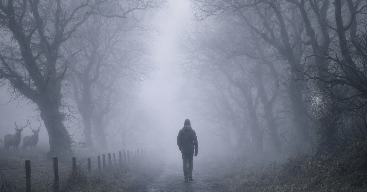
A Cloud You Can Touch
Fog does something peculiar to human perception. It narrows the world without permission, collapsing familiar distances into strange new proximities. Sound moves oddly through fog-saturated air — muffled in one direction, weirdly sharpened in another. Mountains vanish. Cities contract. It’s genuinely disorienting in a way that high-altitude clouds, however dramatic, never quite manage.
And here’s the thing: you can admire a thunderhead from a lawn chair. Fog doesn’t give you that option. It’s already inside your personal space before you’ve had a chance to form an opinion about it.
Ancient cultures blamed spirits and supernatural forces for the effect, and honestly, standing at a crossroads watching solid objects dissolve at twenty meters, it’s hard to argue they were being entirely unreasonable. What’s interesting is that understanding fog scientifically — knowing it’s condensation nuclei and Mie scattering and adiabatic cooling — doesn’t neutralize that feeling.
It compounds it.
Every foggy morning becomes evidence of an atmosphere in active negotiation with temperature and terrain, behaving predictably and surprisingly at once, following rules that took humanity centuries to articulate.
How It Unfolded
- 1803 — Luke Howard publishes his cloud classification system, laying groundwork for understanding fog as a ground-level cloud phenomenon.
- 1859 — The Grand Banks fog disaster involving the SS Royal Charter sharpens maritime awareness of advection fog’s lethal potential.
- 1952 — London’s Great Smog kills an estimated 4,000 people in five days, forcing researchers to connect urban pollution with fog intensity for the first time.
- 2019 — New atmospheric modeling studies confirm that urban condensation nuclei produce measurably smaller, denser fog droplets than rural equivalents, reopening visibility prediction as an active research problem.
By the Numbers
- 1–100 micrometers — typical diameter range of fog and cloud droplets
- Billions per cubic meter — droplet density inside a fog bank or cloud
- 100% — relative humidity at dew point, when condensation begins
- Grand Banks, Newfoundland — among the world’s foggiest regions, averaging over 200 foggy days per year
- 15 km — approximate height a cumulonimbus storm tower can reach above the Pacific — built from the same process as the fog at your ankles
Field Notes
- Fog and clouds share identical formation chemistry — the only structural difference is altitude
- Condensation nuclei (dust, sea salt, pollen, pollution particles) are the invisible scaffolding every droplet requires
- Radiation, advection, and upslope fog each form through distinct pathways but arrive at the same physical result
- Urban environments may intensify fog density through higher particulate concentrations — an area of active, unsettled research
- Mie scattering explains why both fog and clouds appear white or grey against a lit sky
Frequently Asked Questions
- Is fog literally the same as a cloud? Yes — physically identical. Both are masses of tiny water droplets suspended in air, formed when water vapor cools to its dew point around condensation nuclei. The only distinction is location: clouds form at altitude, fog forms at or near ground level.
- Why does fog form more often in valleys? Cold air is denser than warm air and drains downhill overnight. Valley floors collect this cold air naturally, and since cold air reaches saturation more quickly, fog condenses there before it forms on surrounding slopes.
- What makes San Francisco fog so persistent? Cold upwelling water from the California Current chills incoming Pacific air, triggering advection fog that pours through the Golden Gate and across the Bay. The city’s topography traps it. Summer is peak season — warmer inland air creates a pressure gradient that actively pulls fog through coastal gaps.
- Can fog be dangerous? Significantly so. Dense fog reduces visibility to near zero, causing road accidents, maritime collisions, and aviation incidents. The 1952 London smog event — a combination of fog and coal pollution — killed thousands. Urban fog with high particulate content also carries direct respiratory health risks.
- How do meteorologists predict fog? Primarily by tracking dew point, surface temperature, wind speed, and humidity levels. Clear, calm nights following wet days are classic radiation fog setups. Forecasting dense, localized urban fog remains genuinely difficult — current models weren’t built around the condensation nuclei conditions cities now produce.
Editor’s Take — Alex Morgan
What stays with me about fog isn’t the science — it’s the specific feeling of realizing you’re already inside the thing you thought you were looking at. Most of us spend our lives observing weather from a slight remove, treating it as scenery. Fog collapses that distance without asking. The atmosphere reaches down, and suddenly you’re not a spectator anymore. That’s worth something. The fog vs. clouds story isn’t really about meteorology — it’s about what happens when a system that usually operates out of reach decides, briefly, to come to you.
Next time fog rolls through your street, breathe it in — literally. The droplets reaching your lungs formed by the identical process that builds thunderheads over tropical oceans and lays down frost-white cirrus near the poles. You’re not watching the weather from a safe remove. You’re inside it. A cloud has descended, briefly, to ground level — and you happen to be standing there when it arrived. That’s not a metaphor dressed up as science. That’s just meteorology, doing what it does best: making the atmosphere impossible to ignore.
Illustrations are AI-generated. Article fact-checked and human-edited. Our editorial standards.