The Morning Glory Cloud of Burketown: A 1,000 km Wave
At first light on 8 October 2026, a wall of cloud roughly 600 kilometres long came out of the dark over the Gulf of Carpentaria and rolled across a town of a few hundred people — the morning glory cloud of Burketown, the only roll cloud on Earth that arrives often enough, and punctually enough, to plan a trip around. Satellites tracked it from Queensland’s northern interior almost to Groote Eylandt. It had been built the previous evening some 600 kilometres away, over Cape York Peninsula, by two sea breezes running into each other.
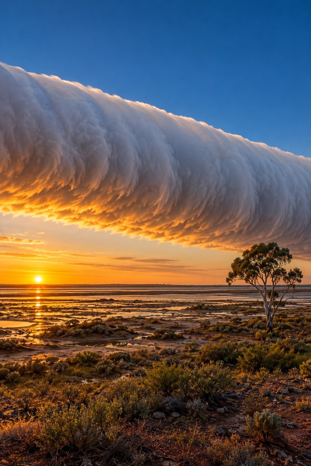
The short answer: the morning glory is not a cloud being blown along — it is a wave travelling through a shallow layer of cool night air, and the cloud is simply the visible crest of that wave, made and unmade continuously as it moves.
- Up to 1,000 km — maximum recorded length of a single cloud line; the 8 October 2026 event measured about 600 km
- 100–200 m — typical height of the cloud base above the ground
- About 1 km — vertical depth of the disturbance; a single roll is 1–2 km across
- 10–20 m/s — propagation speed, or roughly 36–72 km/h
- Up to 10 — consecutive roll clouds observed in a single train
- Over 1 hPa — surface pressure rise as it passes, sometimes within a few minutes
What the morning glory cloud of Burketown actually is

Strip away the spectacle and you are left with fluid mechanics. The morning glory is an undular bore: a step in the depth of a shallow, cool, stable layer of air, travelling along that layer much as a tidal bore travels up a river. Air is forced upward at the leading crest, moisture reaches its condensation level, and cloud appears. A few hundred metres behind, the air sinks again, warms slightly, and the cloud evaporates.
So the roll you photograph is not an object drifting past. It is a shape being manufactured at the front edge and destroyed at the back edge, thousands of times over, while the shape itself holds for hours.
Australian meteorologist Reg Clarke published the first rigorous account in 1972 in the Journal of Applied Meteorology, under a title that still describes the physics honestly: “The Morning Glory: An Atmospheric Hydraulic Jump.” Clarke worked largely from pen-and-ink autographic traces of pressure, wind and temperature recorded at the weather station at Karumba, since abandoned. Later work — in particular by Douglas Christie at the Australian National University, who treated the disturbance as a family of large-amplitude atmospheric solitary waves — gave the phenomenon the description that stuck, and made it a standard reference case for nonlinear waves in the lower atmosphere.
None of which was news locally. The Garrwa people call it kangólgi. Gangalidda traditional owner Murrandoo Yanner has described the morning glory as the work of Walalu, the Rainbow Serpent, and told the ABC that his people regard the clouds as carrying ancestral spirits. Science arrived at the Gulf with instruments in the 1970s; the cloud had a name and a meaning long before that.
Two sea breezes, one collision over Cape York
Why Burketown and nowhere else? Geometry. Cape York Peninsula is a long, narrow finger of land with the Coral Sea on one side and the Gulf of Carpentaria on the other. On a sunny dry-season day both coasts generate a sea breeze, and both breezes march inland. By late afternoon they meet somewhere over the middle of the peninsula, where the cooler easterly flow off the Coral Sea slides underneath the warmer westerly flow coming off the Gulf.
Overnight, a second ingredient appears. Clear skies let the surface radiate heat away, which builds a shallow stable layer of cool air near the ground with a deep, well-mixed layer above it. That sandwich is a waveguide: a stratification that will carry a long wave for hundreds of kilometres with very little loss. The disturbance born over the peninsula gets into it and runs south-west across the Gulf all night, reaching the southern shore around sunrise.
Robert Goler and Michael Reeder, working at Monash University, pinned down the detail that makes the whole machine click: the morning glory is generated by a resonant coupling between the east-coast sea breeze and the waves that can propagate on the shallow stable layer the west-coast sea breeze leaves behind. Their modelling also produced the single most useful operational rule in the literature — background easterly winds of about 10 m/s or less tend to produce the classic, cleanly separated undular bore; stronger easterlies give a rougher, more turbulent bore; and if the easterlies are too strong, no morning glory forms at all.
10 to 20 metres per second — and a pressure jump you can feel
Ground-level passage is abrupt. A wind squall arrives with speeds comparable to the cloud’s own forward speed, the surface pressure can jump by more than a hectopascal in a few minutes, and the wind direction reverses and stays reversed for hours afterwards. Dust lifts. The temperature ticks down. Then the roll passes overhead at an altitude lower than many office towers, and the morning goes quiet again.
A note on the numbers, because they are widely garbled: tourism copy describing the cloud as “1 to 2 kilometres wide and 1,000 kilometres long” has quietly merged two different measurements. The 1–2 km figure is the width of a single roll; the depth of the disturbance is about a kilometre; the 1,000 km is the end-to-end length of the line at its most extreme. Published field measurements put typical speeds at 10–15 m/s, which is where the popular “up to 60 km/h” comes from — and that muddled version now appears online more often than the correct set of figures does.
For a glider, the leading edge is a conveyor belt. Lift sits in a narrow band along the crest, and because the wave does not decay the way a thermal does, it simply keeps giving. Pilots have soared a touring glider more than 700 kilometres in a little over four hours on a single morning glory, much of it over water. In September 2009 Jonny Durand became the first hang-glider pilot to fly it, staying up for an hour and three-quarters across 68 kilometres.
James Cooper, who had been gliding since 1980, flew his last morning glory in October 2022 and put it plainly to the ABC: “It forms much like a wave in the sea. And like a surfer rides a wave coming into the shore, glider pilots can launch into this wave of cloud and fly up and down to take in the view.”
{IMAGE_2}
Three morning glories, not one
Most popular accounts describe a single phenomenon. The research record describes at least three, distinguished by the direction they come from — a distinction that matters a great deal if you are standing on the Burketown wharf road at 5:30 am wondering which horizon to watch.
The north-easterly morning glory is the famous one: the Cape York sea-breeze machine described above, sweeping in from the north-east at or just before dawn. The southerly type is a different animal, associated with the inland heat trough and with cold fronts crossing the continent from the south; it was documented in unusual detail during the Gulf Lines Experiment of September 2002, run jointly by Australia’s Bureau of Meteorology, Monash University and the University of Munich. A rarer south-easterly type shows up in tangled synoptic situations, occasionally with several disturbances aloft at once — Weatherzone has reported twin sets crossing the Gulf together.
Field campaigns in the Gulf have a long lineage: a 1979 expedition led by Reg Clarke and Roger Smith, which caught three events at Burketown between 23 September and 8 October; a return in 1982 with radiosondes and aircraft humidity sensors; then the Gulf Lines Experiment in 2002 and two follow-ups in 2005 and 2006 using Doppler sodars and small autonomous aircraft. In 2014 a team including Thomas Peacock of MIT’s Environmental Dynamics Lab and Jörg Hacker of Airborne Research Australia at Flinders University presented the morning glory in Physics of Fluids as something close to a gift to their field — a stratified-fluid wave made visible, at full scale, by its own condensation.
Roll cloud, shelf cloud or morning glory?
All three look like a long horizontal cloud bar advancing on you, and they get confused constantly in news captions. The mechanisms are not the same, and one of them is a thunderstorm warning sign while another is a dawn curiosity.
| Feature | Morning glory | Storm roll cloud | Shelf cloud |
|---|---|---|---|
| Driver | Undular bore on a nocturnal stable layer | Thunderstorm outflow, detached from the storm | Storm outflow still attached to the updraught base |
| Parent storm? | None | Yes, usually behind it | Yes, directly above and behind |
| Typical scale | Hundreds of km, up to 1,000 km | Tens of km | Tens of km |
| Timing | Dawn; gone by mid-morning | Whenever a storm is nearby | Whenever a storm is nearby |
| What follows | Wind squall, pressure rise, clearing sky | Gusts, often rain | Strong gust front, then heavy rain |
| Predictable? | Yes — uniquely so, in the southern Gulf of Carpentaria | Only as far as the storm is | Only as far as the storm is |
85 per cent: the odds of catching one
Morning glories have been reported from the central United States, the English Channel, Nova Scotia, the Gulf of California, the Arabian Sea, Brazil, South Africa, and the skies over Munich and Berlin. What makes the southern Gulf of Carpentaria unique is not that the wave happens there, but that it happens there on a timetable. When Australia’s mesoscale forecast system MesoLAPS was tested against observed events, roughly 85 per cent of its north-easterly morning glory forecasts verified, with the predicted orientation of the cloud line accurate to a standard deviation of about six degrees and arrival timing within an hour in about half of cases. It missed around 15 per cent of north-easterly events outright, and southerly ones proved much harder — six of eleven were not forecast at all.
Peak season runs from early September to about mid-November, with the highest frequency from late September into early November. October is the month most visitors aim for, and dawn is the only time of day worth setting an alarm for: once the sun heats the ground, the shallow stable layer that carries the wave is mixed away and the cloud evaporates.
Burketown’s own rule of thumb is cruder and surprisingly defensible. If a brisk sea breeze has been blowing through town all afternoon and the night is clear and calm, the odds are good. Turns out the other half of the local test — that the pub fridges frost over — is a rough proxy for exactly the conditions the physics needs: humid, cool, stable air sitting at the surface. Not a forecast model. But not nonsense either.
Quick Answers
When is the best time to see the morning glory cloud at Burketown? Late September to early November, with October the most reliable month, and only at or just before sunrise. Events are typically over within a couple of hours of first light.
Does the morning glory happen anywhere else? Yes — similar roll clouds have been documented on several continents. The southern Gulf of Carpentaria is the only place where they recur predictably enough to be forecast and chased.
Is the passing cloud dangerous? The cloud itself is low and benign, but the wave brings a sudden wind squall, a quick pressure rise and a wind reversal — which is why light aircraft, small boats and campers around the Gulf treat it as a squall event and follow the Bureau of Meteorology’s forecasts for the day.
Why does it only appear at dawn? Because it needs the night. The stable layer of cool surface air that acts as the waveguide is created by overnight radiative cooling, and it is destroyed by morning sunshine. No night-time inversion, no morning glory.
Sources and Notes
- Journal of Applied Meteorology, American Meteorological Society — R. H. Clarke, “The Morning Glory: An Atmospheric Hydraulic Jump” (1972)
- Monthly Weather Review and Journal of the Atmospheric Sciences, American Meteorological Society — including Goler and Reeder on eastward-propagating undular bores over Cape York Peninsula
- Meteorological Institute, Ludwig-Maximilians-Universität München — Roger K. Smith’s Morning Glory and Gulf Lines Experiment project archive
- Physics of Fluids, American Institute of Physics (2014) — “The Morning Glory: Flow visualization by Mother Nature”
- Weatherzone and the Australian Bureau of Meteorology (satellite reporting of the October 2026 event); ABC News Australia (gliding and Gangalidda Garawa reporting)
The 2026 season still has weeks to run, and the Gulf is now watched by satellites and automatic weather stations that register events nobody is awake to photograph — which makes it easier to admit how much is still unsettled. No one can yet say why some seasons deliver a dozen clean morning glories and others almost none, or how a warmer, more humid Gulf will alter the thin layer of night air the wave depends on. For now the recipe holds: a hot peninsula, two sea breezes, a clear still night, and a town willing to get up in the dark.
Illustrations are AI-generated. Article fact-checked and human-edited. Our editorial standards.