How China Restored the Loess Plateau: The 2009 Turning Point
How China restored the Loess Plateau is no longer a question with a single answer — it is the most-studied ecological turnaround in modern history, and by the end of 2009 a degraded region roughly the size of Belgium had visibly flipped from dust-bowl to green on satellite imagery. A retired CBS cameraman named John D. Liu had filmed nearly every step.
Key Facts
- About 35,080 km² (3.5 million hectares) of degraded watersheds were rehabilitated under the World Bank’s Loess Plateau Watershed Rehabilitation Project by 2005, across 1,223 small sub-basins.
- Vegetation cover in the core project area roughly doubled — from about 17% to 34% — and Yellow River sediment fell by more than 100 million tons per year.
- The work rested on three techniques: bench terraces, check dams, and Grain-for-Green payments to farmers who retired sloping cropland.
- John D. Liu, a Beijing-based ex-CBS cameraman, began filming for the World Bank in 1995; his documentary Hope in a Changing Climate premiered on BBC World on 27 November 2009 and screened at COP15 in Copenhagen weeks later.
- The hidden bill, quantified by Feng et al. (2016, Nature Climate Change) and Evaristo et al. (2026, WIREs Water): the new forests are drawing down deep soil water faster than rainfall can refill it, and river runoff is falling.
In short: Between 1994 and 2009 China rebuilt the most eroded land on Earth using terraces, check dams and direct payments to farmers, lifted 2.5 million people out of poverty, and cut Yellow River sediment by a hundred million tons a year. Two decades later, peer-reviewed work shows the same restoration is now overdrawing the plateau’s deep groundwater — a real success, with a real bill.
Key Facts
- About 35,080 km2 (3.5 million hectares) of degraded watersheds were rehabilitated under the World Bank’s Loess Plateau Watershed Rehabilitation Project by 2005, across 1,223 small sub-basins.
- Vegetation cover in the core project area roughly doubled from about 17% to 34%, and Yellow River sediment fell by more than 100 million tons per year.
- The restoration rested on three techniques: bench terraces, check dams, and Grain-for-Green payments to farmers who retired sloping cropland.
- John D. Liu, a Beijing-based ex-CBS cameraman, began filming for the World Bank in 1995, and his documentary Hope in a Changing Climate premiered on BBC World on 27 November 2009 before screening at COP15 in Copenhagen.
- Peer-reviewed work by Feng et al. (2016, Nature Climate Change) and Evaristo et al. (2026, WIREs Water) found the new forests are drawing down deep soil water faster than rainfall can refill it, so river runoff is falling.
In short: Between 1994 and 2009 China rebuilt the most eroded land on Earth using terraces, check dams and direct payments to farmers, lifting 2.5 million people out of poverty and cutting Yellow River sediment by roughly a hundred million tons a year. Two decades later, peer-reviewed research shows the same restoration is now overdrawing the plateau’s deep groundwater. It remains a real success with a real bill.
How China restored the Loess Plateau: the 2009 moment a dust-bowl turned green

The Loess Plateau covers about 640,000 square kilometres across seven Chinese provinces. Its surface is loess — fine, wind-deposited silt, in places more than 300 metres deep — and by the early 1990s it was being washed off so fast that the region had a nickname: “China’s Sorrow.” Roughly 95% of rainfall ran straight off the bare slopes as mud.
By the end of 2009, a different label fit: the world’s largest successful ecosystem restoration. A degraded watershed area roughly the size of Belgium was visibly green from orbit. The Yellow River was carrying about a hundred million tons less sediment per year than it had a decade earlier. And on BBC World, a documentary called Hope in a Changing Climate was about to put the project in front of every climate negotiator at COP15 Copenhagen.
This is the story of how it actually happened — the engineering, the cameraman, the books on poverty, and the increasingly serious bill that the same restoration is now sending back upstairs.
‘China’s Sorrow’: how a fertile cradle became the world’s most eroded land
The Loess Plateau is where Chinese civilization began. The Yangshao culture grew millet on it 7,000 years ago. The Zhou and Qin dynasties built their first capitals on it. Loess soil is unusually fertile — fine, porous, easy to till — and that is exactly why it failed.
For three thousand years the plateau was cleared, ploughed, grazed and re-grazed. By the twentieth century its surface was a maze of gullies cut hundreds of metres down through bare silt. The plateau was shedding on the order of 1.6 billion tons of sediment a year and shipping most of it into the Yellow River, which itself sat on a bed raised metres above the surrounding farmland behind levees. Floods were catastrophic and routine. Per-capita farm incomes in the worst counties — parts of Gansu, Shaanxi, Shanxi and Inner Mongolia — hovered around $70 a year.
That is the baseline. Any honest account of what came next has to start from how bad it was.
The three-legged stool: terraces, check dams, and Grain-for-Green
The restoration was not one program. It was two overlapping ones, leaning on the same three techniques.
The first was the World Bank–financed Loess Plateau Watershed Rehabilitation Project, launched in 1994 with a Phase 1 commitment of about $252 million and extended in Phase 2 for a combined investment of around $550 million through 2005. The second was Grain-for-Green (退耕还林), the national program Beijing launched in 1999 after the catastrophic 1998 Yangtze floods. World Bank engineering became the template; Grain-for-Green made it national policy.
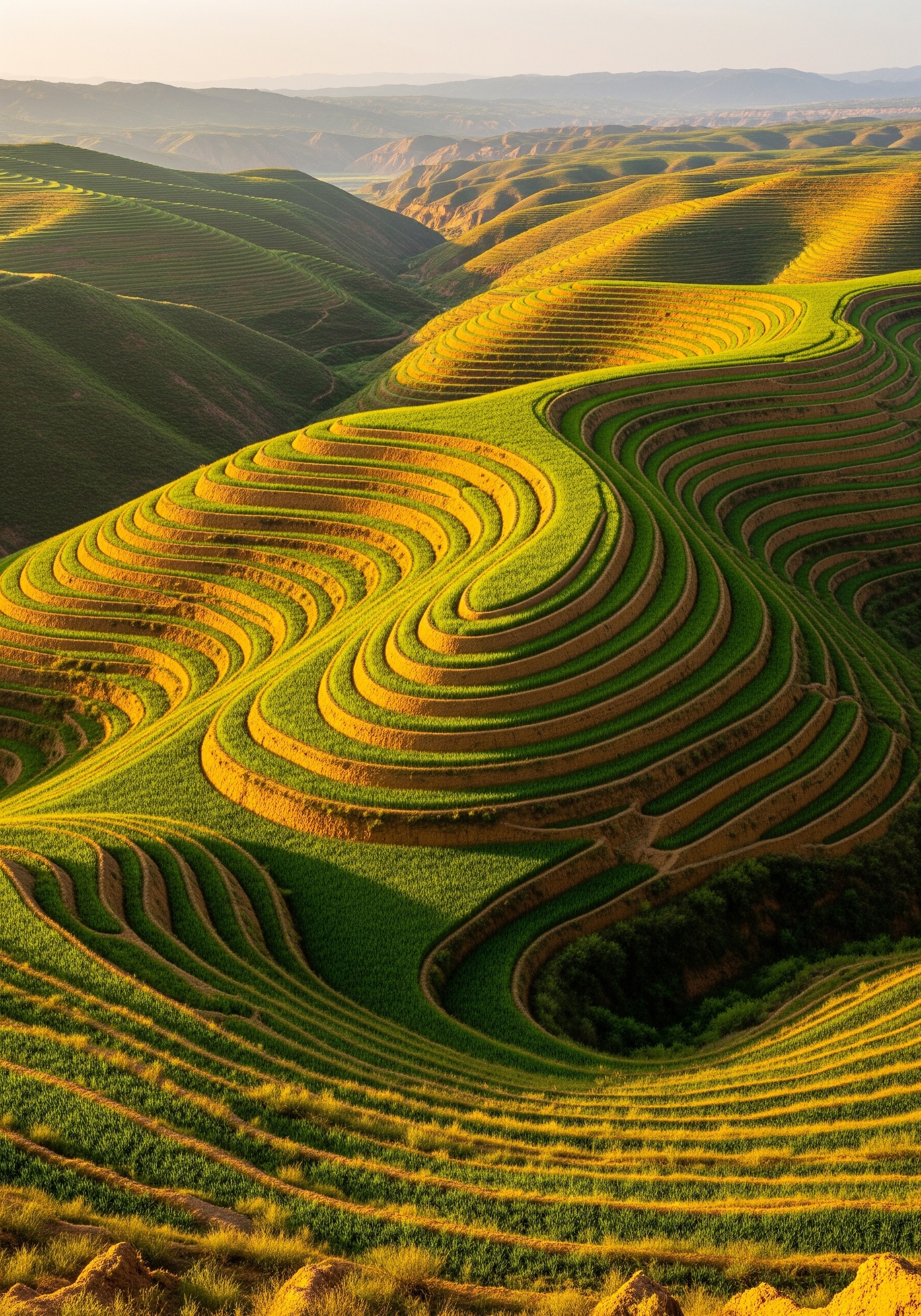
Three things did the heavy lifting on the ground. Bench terraces — cut into hillsides above roughly 25° to turn each slope into a staircase of flat fields, dramatically slowing runoff. Check dams — small embankments with a spillway and an outlet, built across gullies so that the next mud surge dropped its load behind the dam and built new flat farmland instead of disappearing downstream. And Grain-for-Green payments — annual cash plus grain, delivered for years, to farmers who took their steepest cropland out of grain and let it revert to forest, shrub or grass. The payment was the political masterstroke. It made the right ecological choice the most profitable choice for an individual farmer.
Systematic reviews of the work put rough effectiveness shares at about two-thirds for revegetation, two-thirds for terraces, and under 10% for check dams alone. None of the three did it on its own. Together, they did.
{IMAGE_2}
The cameraman who showed the world: John D. Liu, 1995–2009
John Dennis Liu was a CBS News cameraman based in Beijing in the 1980s. In 1995 the World Bank hired him to make a baseline film of the new Loess Plateau project. He kept going back, year after year, for the next fourteen years. By the time he stopped he had on the order of a hundred hours of original footage — the same valleys, the same families, photographed across a decade and a half.
Liu’s first big edit, The Lessons of the Loess Plateau, came out in 2009 through the Environmental Education Media Project. The companion film, Hope in a Changing Climate — co-produced with BBC World, IUCN, The Open University and the World Bank — premiered on BBC World on 27 November 2009 and screened in Copenhagen weeks later, where every COP15 delegate could see the before-and-after for themselves. Almost everything the wider public “knows” about the restoration — the bare yellow gullies, the green terraces, the same farmer in 1995 and in 2008 — comes through Liu’s lens.
One detail worth keeping straight: Liu is the messenger, not the engineer. The restoration was designed and run by Chinese hydrologists, county officials and several million farmers. Liu’s contribution was to make the rest of the world able to see it. Without that footage, the project would have been a World Bank PDF. Because of it, the project became a template.
The ledger by 2009 — and a note on the “2,100 hectares” myth
The single most common error you will find online is a figure of “2,100 hectares restored.” It is wrong by roughly three orders of magnitude — almost certainly a number miscopied from somewhere and then re-copied by everyone downstream. The real ledger, from the World Bank’s own 2007 feature story and the project completion reports, looks like this.
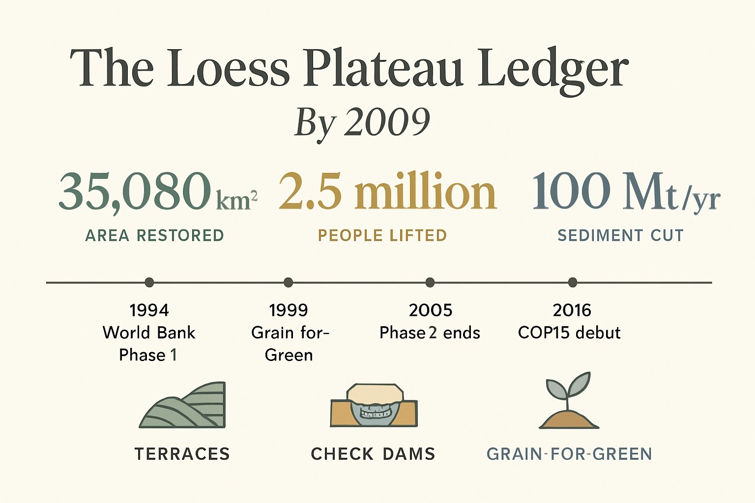
The Loess Plateau ledger by 2009
- Area restored — World Bank project (1994–2005): ~35,080 km² (3,508,000 hectares) of degraded watershed across 1,223 small sub-basins.
- Area retired — Grain-for-Green (1999–2016, broader program): ~29,800 km² (≈11,500 sq mi) of sloping cropland converted to forest, shrub or grass.
- Vegetation cover in the core project area: ≈17% → ≈34%.
- Yellow River sediment load: reduced by >100 million tons per year.
- Cost: ~$252M Phase 1; ~$550M total commitment to 2005.
- People moved above the poverty line: ~2.5 million.
- Per-capita rural income, core counties: ~$70/year → ~$200/year (World Bank, 2007).
The two area figures — 35,080 km² and 11,500 sq mi — are not contradictions. They measure different things over different timeframes: the World Bank’s number is total watershed area treated by 2005; the 11,500 sq mi is sloping cropland specifically retired under Grain-for-Green by 2016. Both are right. Anything calling the project “2,100 hectares” should be treated as recycled, unverified text.
The hidden bill: why the green Loess Plateau is now drying out underneath
This is the section the cheerful explainers tend to skip. The new vegetation is real. So is the cost of it.
Peer-reviewed work led by Xiaoming Feng of the Chinese Academy of Sciences, published in Nature Climate Change in 2016 (Feng et al., 6: 1019–1022), measured the trade-off directly. New planting raised net primary productivity, as you would hope — but it also raised evapotranspiration so steeply that across most catchments the ratio of river runoff to annual rainfall fell. In plain words: the new forest is breathing more rain back into the sky as vapour, and less of it is reaching the streams. The paper’s conclusion was the title: revegetation in the region was already “approaching sustainable water resource limits.”
A 2026 review by Jaivime Evaristo at the University of Georgia, in WIREs Water — “Left High and Dry: Deep Soil Water Depletion and Ecohydrological Resilience on China’s Loess Plateau” — pushed the picture deeper, literally. Evaristo and colleagues pulled together four lines of evidence: bomb-peak tritium tracers showing rainfall from the 1960s still slowly migrating through subsurface layers 7–14 metres down; afforestation species whose roots reach 5–15 metres; and the consistent finding that deep soil water is functionally exhausted within 15 to 25 years of planting. The reservoir the planting initially drew on is finite, and a lot of it is now gone.
That is the bill. The plateau looks restored from a helicopter. Underneath, much of it is now running on borrowed water.
And here is the editorial judgement worth saying plainly: the Loess Plateau restoration is, almost certainly, the most consequential land repair in human history — and treating it as a finished success rather than a system that now needs adaptive thinning, mixed species and rainwater harvesting is exactly how a second-generation failure happens.
The downstream paradox: a delta that is starting to shrink
There is one more bill, paid at the other end of the river. The Yellow River had carried so much sediment for so long that its delta on the Bohai Sea was one of the fastest-growing pieces of new land in Asia — fresh, accreting mud, building outward into the sea every year.
Cut the sediment by a hundred million tons a year upstream — which the restoration did, and which is unambiguously good for the river, the levees and the cities downstream — and the delta starves. Turns out a coastline can be built by erosion somewhere else. Recent coastal surveys report that parts of the delta are now eroding back into the Bohai Sea instead of growing outward. The upstream win is, slowly, unmaking the downstream coastline.
Neither effect cancels the other. The upstream gains in farmland, water clarity and flood safety are enormous. The downstream loss is a real, measurable secondary cost that the original project plans did not anticipate, because nobody in 1994 expected the sediment cut to be this complete.
Lessons the world is still learning
Three things the rest of the world should take from the plateau, stated honestly.
First, ecosystem restoration at continental scale is possible. Anyone still arguing it isn’t is arguing against satellite imagery.
Second, monoculture is a trap. The first wave of planting leaned heavily on a single species — Robinia pseudoacacia, black locust — because it was hardy, nitrogen-fixing and cheap. The result was green from the air and biologically thin on the ground. The mid-2010s pivot toward mixed-species plantings was a course correction that the early reporting largely missed.
Third, every restoration has a water budget. The plateau’s deep-soil drawdown is not a defeat; it is the invoice arriving. The same engineering exported to Ethiopia, Rwanda or the Sahel will hit the same ceiling unless its planners design for evapotranspiration from day one — fewer trees per hectare in dry zones, mixed natives instead of nitrogen-fixers everywhere, rainwater harvesting upstream of the planting, and rotational thinning before the stand outgrows its water supply.
That is the next chapter. It is being written now, in studies like Evaristo’s, and by Chinese provincial foresters who are already replanting the replantings.
Frequently Asked Questions
Q: How much of the Loess Plateau was actually restored?
A: About 35,080 km² (≈3.5 million hectares) of watershed land under the World Bank project completed in 2005, and about 29,800 km² (≈11,500 sq mi) of sloping cropland under the national Grain-for-Green program by 2016. The “2,100 hectares” figure you sometimes see online is wrong by three orders of magnitude.
Q: Who is John D. Liu?
A: An American ex-CBS cameraman based in Beijing who began filming the plateau for the World Bank in 1995. His 2009 documentary Hope in a Changing Climate (BBC World, premiered 27 November 2009; screened at COP15 Copenhagen) is what made the restoration globally famous. Liu is a chronicler, not an engineer; the work itself was done by Chinese hydrologists, officials and farmers.
Q: Did the Loess Plateau restoration actually work?
A: On its original goals — soil retention, flood control and rural poverty reduction — emphatically yes. But peer-reviewed work since 2016 (Feng et al., Nature Climate Change) and 2026 (Evaristo et al., WIREs Water) has documented serious side-effects: falling river runoff and deep-soil-water depletion under the new forests, and erosion of the Yellow River delta downstream. It worked, and it now needs adaptive management.
Q: What were the three techniques used?
A: Bench terraces on steep slopes, check dams across gullies, and Grain-for-Green payments to farmers who retired their sloping cropland to forest, shrub or grass. None of the three did it alone; together they did.
Sources
- World Bank (2007). Restoring China’s Loess Plateau (feature story); and Loess Plateau Watershed Rehabilitation Project completion reports, 2005.
- Feng, X., Fu, B., Piao, S., et al. (2016). Revegetation in China’s Loess Plateau is approaching sustainable water resource limits. Nature Climate Change 6: 1019–1022.
- Evaristo, J. et al. (2026). Left High and Dry: Deep Soil Water Depletion and Ecohydrological Resilience on China’s Loess Plateau. WIREs Water (Wiley).
- Liu, J.D. (2009). Hope in a Changing Climate. Environmental Education Media Project, BBC World, IUCN, The Open University, World Bank. Premiered BBC World, 27 November 2009; screened UNFCCC COP15, Copenhagen.
- Wang, S. et al. (2022). Ecological restoration stimulates environmental outcomes but exacerbates water shortage in the Loess Plateau (PMC9272815).
The Loess Plateau is the rarest thing in environmental writing: a story where the headline (“they fixed it”) is true, and the footnote (“at a cost they are only now measuring”) is also true. Both belong in the same article. The next thirty years of restoration science — on this plateau, and on the half-dozen others now copying its playbook — will be a fight to keep the win without paying that footnote in full.
Illustrations are AI-generated. Article fact-checked and human-edited. Our editorial standards.